Reinach night lights from space
Night Light of Reinach (Aargau) from space (Switzerland) Src. Average luminocity for 10x10km area is 9.9628% and for 50x50km: 16.768%.
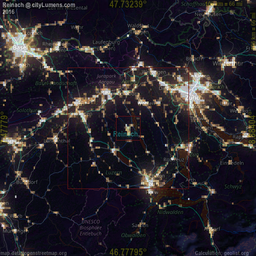
Analysis of Reinach night lights 2016
Square area 10x10 km:
100  0%
0%
90-99 0.6%
80-89 1.19%
70-79 2.68%
60-69 1.49%
50-59 1.49%
40-49 1.49%
30-39 1.34%
20-29 1.34%
10-19 1.34%
0-9 87.05%
0%90-99
0.6%80-89
1.19%70-79
2.68%60-69
1.49%50-59
1.49%40-49
1.49%30-39
1.34%20-29
1.34%10-19
1.34%0-9
87.05%Square area 50x50 km:
100 1.79%
90-99 2.34%
80-89 1.27%
70-79 1.7%
60-69 2.67%
50-59 2.27%
40-49 2.76%
30-39 2.87%
20-29 5.37%
10-19 17.13%
0-9 59.84%
1.79%90-99
2.34%80-89
1.27%70-79
1.7%60-69
2.67%50-59
2.27%40-49
2.76%30-39
2.87%20-29
5.37%10-19
17.13%0-9
59.84%Clear (daylight) street map image can be seen on geolist.org.
Map coordinates:
47° 43' 56.6" North, 7° 28' 40" East
47° 15' 26.4" North, 8° 10' 51.3" East
46° 46' 40.6" North, 8° 53' 2.5" East
Some cities around Reinach sort by population:
• Wohlen
12.6 km =7.8 mi,  34°
34°
• Hochdorf
13 km =8.1 mi,  139°
139°
• Sursee
11 km =6.8 mi,  208°
208°
• Lenzburg
14.6 km =9.1 mi,  358°
358°
• Gränichen
12.8 km =8 mi,  332°
332°
• Muri
12 km =7.5 mi,  80°
80°
• Villmergen
11.5 km =7.1 mi, 25°
• Menziken
2.1 km =1.3 mi,  160°
160°
2659076 (p: 7,845)
Sources (retrieved 2019-11-25):
» Earth at Night: Flat Maps 2012, 2016