Muri night lights from space
Night Light of Muri (Aargau) from space (Switzerland) Src. Average luminocity for 10x10km area is 5.9048% and for 50x50km: 19.7767%.
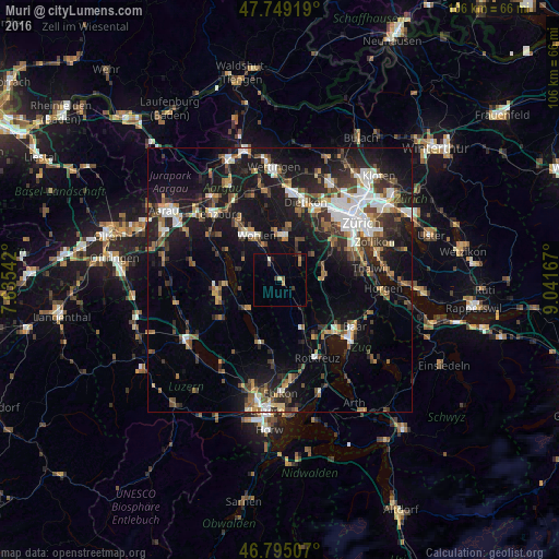
Analysis of Muri night lights 2016
Square area 10x10 km:
 0%
0%90-99
0.6%80-89
0.6%70-79
1.04%60-69
0.89%50-59
0.45%40-49
1.19%30-39
0.89%20-29
0.6%10-19
1.64%0-9
92.11%Square area 50x50 km:
2.89%90-99
3.18%80-89
1.4%70-79
1.65%60-69
2.79%50-59
2.75%40-49
3.31%30-39
3.43%20-29
5.67%10-19
17.64%0-9
55.29%Clear (daylight) street map image can be seen on geolist.org.
Map coordinates:
47° 44' 57.1" North, 7° 38' 7.5" East
47° 16' 27.4" North, 8° 20' 18.7" East
46° 47' 42.3" North, 9° 2' 30" East
Some cities around Muri sort by population:
• Wohlen
9.7 km =6 mi,  330°
330°
• Hünenberg
12.8 km =8 mi,  149°
149°
• Affoltern am Albis
8.5 km =5.3 mi,  87°
87°
• Hochdorf
12.3 km =7.6 mi,  196°
196°
• Reinach
12 km =7.5 mi,  260°
260°
• Bremgarten
8.5 km =5.3 mi,  1°
1°
• Villmergen
10.9 km =6.8 mi,  320°
320°
• Menziken
11.9 km =7.4 mi,  251°
251°
2659531 (p: 6,463)
Sources (retrieved 2019-11-25):
» Earth at Night: Flat Maps 2012, 2016