Chêne-Bougeries night lights from space
Night Light of Chêne-Bougeries (Geneva) from space (Switzerland) Src. Average luminocity for 10x10km area is 67.5384% and for 50x50km: 18.4314%.
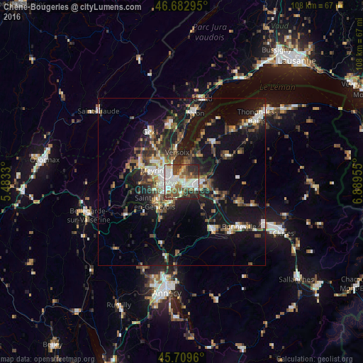
Analysis of Chêne-Bougeries night lights 2016
Square area 10x10 km:
 18.75%
90-99
19.18%80-89
4.69%70-79
5.68%60-69
7.53%50-59
9.38%40-49
13.07%30-39
8.38%20-29
13.07%10-19
0.28%0-9
0%Square area 50x50 km:
2.31%90-99
3.12%80-89
1.28%70-79
1.61%60-69
2.28%50-59
2.78%40-49
3.6%30-39
3.46%20-29
4.99%10-19
18.16%0-9
56.41%Clear (daylight) street map image can be seen on geolist.org.
Map coordinates:
46° 40' 58.6" North, 5° 28' 59.9" East
46° 11' 54.3" North, 6° 11' 11.1" East
45° 42' 34.6" North, 6° 53' 22.4" East
Some cities around Chêne-Bougeries sort by population:
• Genève
3.2 km =2 mi,  277°
277°
• Annemasse, FR
4 km =2.5 mi,  96°
96°
• Lancy
5.6 km =3.5 mi,  260°
260°
• Carouge
4.1 km =2.5 mi,  241°
241°
• Thônex
1.5 km =0.9 mi,  139°
139°
• Gaillard, FR
2.2 km =1.4 mi,  132°
132°
• Veyrier
3.5 km =2.2 mi,  182°
182°
• Ville-la-Grand, FR
4.9 km =3 mi,  84°
84°
3209498 (p: 10,487)
Sources (retrieved 2019-11-25):
» Earth at Night: Flat Maps 2012, 2016