Sumiswald night lights from space
Night Light of Sumiswald (Bern) from space (Switzerland) Src. Average luminocity for 10x10km area is 0.5241% and for 50x50km: 7.8674%.
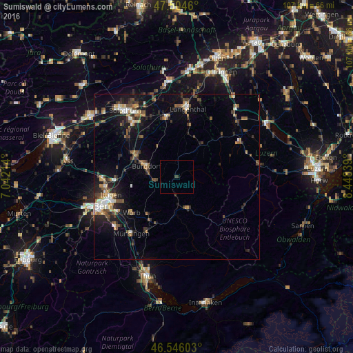
Analysis of Sumiswald night lights 2016
Square area 10x10 km:
 0%
0%90-99
0%80-89
0%70-79
0%60-69
0%50-59
0%40-49
0%30-39
1.14%20-29
0%10-19
0%0-9
98.86%Square area 50x50 km:
0.68%90-99
1.08%80-89
0.66%70-79
0.71%60-69
1.14%50-59
1.31%40-49
1.47%30-39
1.52%20-29
1.98%10-19
5.68%0-9
83.76%Clear (daylight) street map image can be seen on geolist.org.
Map coordinates:
47° 30' 16.6" North, 7° 2' 31.7" East
47° 1' 38.9" North, 7° 44' 42.9" East
46° 32' 45.7" North, 8° 26' 54.2" East
Some cities around Sumiswald sort by population:
• Burgdorf
9.6 km =6 mi,  291°
291°
• Langenthal
21.2 km =13.2 mi,  10°
10°
• Worb
17.6 km =10.9 mi,  231°
231°
• Langnau
10.3 km =6.4 mi,  161°
161°
• Bolligen
19.7 km =12.2 mi,  252°
252°
• Herzogenbuchsee
18.1 km =11.2 mi,  350°
350°
• Kirchberg
13.9 km =8.6 mi,  297°
297°
• Urtenen
18.5 km =11.5 mi,  269°
269°
2658449 (p: 5,159)
Sources (retrieved 2019-11-25):
» Earth at Night: Flat Maps 2012, 2016