Urtenen night lights from space
Night Light of Urtenen (Bern) from space (Switzerland) Src. Average luminocity for 10x10km area is 17.5128% and for 50x50km: 11.6767%.
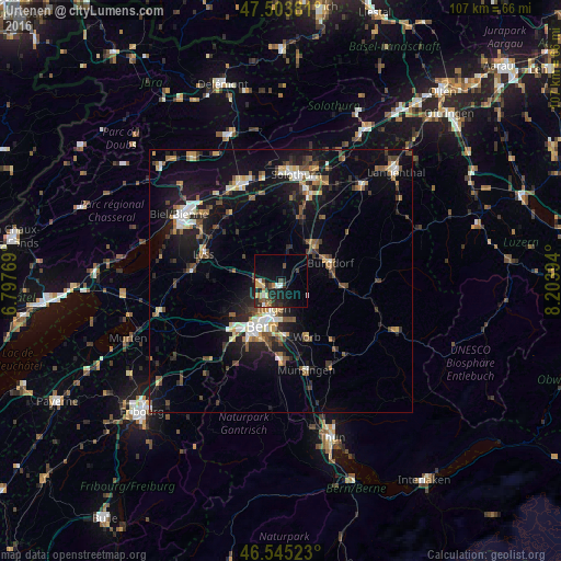
Analysis of Urtenen night lights 2016
Square area 10x10 km:
 1.42%
1.42%90-99
1.7%80-89
1.85%70-79
2.27%60-69
2.13%50-59
0.99%40-49
3.98%30-39
3.27%20-29
7.95%10-19
15.48%0-9
58.95%Square area 50x50 km:
1.09%90-99
1.71%80-89
1.14%70-79
1.14%60-69
1.41%50-59
1.59%40-49
1.95%30-39
1.96%20-29
3.29%10-19
10.83%0-9
73.9%Clear (daylight) street map image can be seen on geolist.org.
Map coordinates:
47° 30' 13.7" North, 6° 47' 51.7" East
47° 1' 36" North, 7° 30' 2.9" East
46° 32' 42.8" North, 8° 12' 14.2" East
Some cities around Urtenen sort by population:
• Bern
9.6 km =6 mi,  204°
204°
• Burgdorf
10.3 km =6.4 mi,  69°
69°
• Muri
10.7 km =6.6 mi,  185°
185°
• Worb
11.8 km =7.3 mi,  156°
156°
• Münchenbuchsee
3.9 km =2.4 mi,  261°
261°
• Zollikofen
4.5 km =2.8 mi,  226°
226°
• Bolligen
5.7 km =3.5 mi,  182°
182°
• Kirchberg
9 km =5.6 mi,  43°
43°
2658217 (p: 5,258)
Sources (retrieved 2019-11-25):
» Earth at Night: Flat Maps 2012, 2016