Langenthal night lights from space
Night Light of Langenthal (Bern) from space (Switzerland) Src. Average luminocity for 10x10km area is 15.3973% and for 50x50km: 11.6235%.
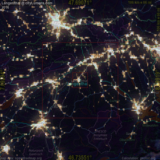
Analysis of Langenthal night lights 2016
Square area 10x10 km:
 1.04%
1.04%90-99
1.34%80-89
1.19%70-79
0.89%60-69
2.83%50-59
2.83%40-49
3.42%30-39
4.02%20-29
0.74%10-19
12.5%0-9
69.2%Square area 50x50 km:
0.98%90-99
1.59%80-89
0.73%70-79
1.12%60-69
1.83%50-59
1.75%40-49
1.92%30-39
2.04%20-29
3.44%10-19
11.11%0-9
73.5%Clear (daylight) street map image can be seen on geolist.org.
Map coordinates:
47° 41' 26.6" North, 7° 5' 34.6" East
47° 12' 54.9" North, 7° 47' 45.9" East
46° 44' 7.8" North, 8° 29' 57.1" East
Some cities around Langenthal sort by population:
• Olten
17 km =10.6 mi,  28°
28°
• Zofingen
13.9 km =8.6 mi,  54°
54°
• Oftringen
14.7 km =9.1 mi,  41°
41°
• Rothrist
12.3 km =7.6 mi, 35°
• Aarburg
14.1 km =8.8 mi, 33°
• Derendingen
15.8 km =9.8 mi,  263°
263°
• Balsthal
13.6 km =8.5 mi,  325°
325°
• Herzogenbuchsee
7.4 km =4.6 mi,  245°
245°
2660034 (p: 14,184)
Sources (retrieved 2019-11-25):
» Earth at Night: Flat Maps 2012, 2016