Collombey night lights from space
Night Light of Collombey (Valais) from space (Switzerland) Src. Average luminocity for 10x10km area is 21.2292% and for 50x50km: 6.3509%.
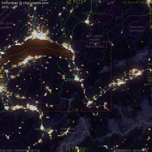
Analysis of Collombey night lights 2016
Square area 10x10 km:
 3.13%
3.13%90-99
4.02%80-89
2.08%70-79
0.74%60-69
2.53%50-59
3.27%40-49
2.23%30-39
3.27%20-29
1.04%10-19
28.13%0-9
49.55%Square area 50x50 km:
0.46%90-99
0.82%80-89
0.62%70-79
0.77%60-69
0.71%50-59
1.1%40-49
1.1%30-39
0.81%20-29
0.77%10-19
4.52%0-9
88.31%Clear (daylight) street map image can be seen on geolist.org.
Map coordinates:
46° 45' 27.7" North, 6° 14' 41.2" East
46° 16' 25.9" North, 6° 56' 52.4" East
45° 47' 8.5" North, 7° 39' 3.7" East
Some cities around Collombey sort by population:
• Montreux
17.9 km =11.1 mi,  351°
351°
• Monthey
2.2 km =1.4 mi,  167°
167°
• Martigny-Ville
21.3 km =13.2 mi,  153°
153°
• La Tour-de-Peilz
21.1 km =13.1 mi,  341°
341°
• Aigle
5.1 km =3.2 mi,  14°
14°
• Ollon
4.2 km =2.6 mi,  55°
55°
• Bex
5.5 km =3.4 mi,  119°
119°
• Fully
19.8 km =12.3 mi,  139°
139°
2661148 (p: 5,926)
Sources (retrieved 2019-11-25):
» Earth at Night: Flat Maps 2012, 2016