Balsthal night lights from space
Night Light of Balsthal (Solothurn) from space (Switzerland) Src. Average luminocity for 10x10km area is 13.0774% and for 50x50km: 14.046%.
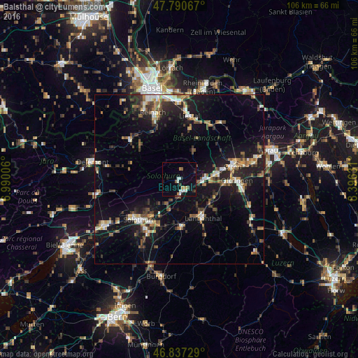
Analysis of Balsthal night lights 2016
Square area 10x10 km:
 1.64%
1.64%90-99
3.13%80-89
0.45%70-79
1.49%60-69
1.04%50-59
1.19%40-49
1.34%30-39
1.04%20-29
1.34%10-19
8.04%0-9
79.32%Square area 50x50 km:
1.19%90-99
2.05%80-89
1.14%70-79
1.56%60-69
1.97%50-59
2.04%40-49
1.89%30-39
2.54%20-29
3.97%10-19
13.21%0-9
68.46%Clear (daylight) street map image can be seen on geolist.org.
Map coordinates:
47° 47' 26.4" North, 6° 59' 24.2" East
47° 18' 58.1" North, 7° 41' 35.4" East
46° 50' 14.2" North, 8° 23' 46.7" East
Some cities around Balsthal sort by population:
• Olten
16.3 km =10.1 mi,  76°
76°
• Langenthal
13.6 km =8.5 mi,  145°
145°
• Zuchwil
15.9 km =9.9 mi,  216°
216°
• Rothrist
15 km =9.3 mi,  94°
94°
• Aarburg
15.6 km =9.7 mi, 88°
• Trimbach
15.6 km =9.7 mi,  69°
69°
• Derendingen
15.3 km =9.5 mi,  211°
211°
• Herzogenbuchsee
14.3 km =8.9 mi,  176°
176°
2661626 (p: 5,863)
Sources (retrieved 2019-11-25):
» Earth at Night: Flat Maps 2012, 2016