Shannon night lights from space
Night Light of Shannon (Quebec) from space (Canada) Src. Average luminocity for 10x10km area is 19.1607% and for 50x50km: 19.0207%.
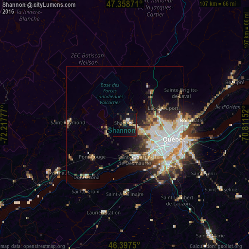
Analysis of Shannon night lights 2016
Square area 10x10 km:
 0.89%
0.89%90-99
3.57%80-89
4.61%70-79
1.79%60-69
1.19%50-59
2.08%40-49
1.34%30-39
1.49%20-29
4.61%10-19
28.27%0-9
50.15%Square area 50x50 km:
4.8%90-99
4.81%80-89
1.76%70-79
1.94%60-69
1.92%50-59
1.95%40-49
2.4%30-39
2.39%20-29
3.76%10-19
5.74%0-9
68.53%Clear (daylight) street map image can be seen on geolist.org.
Map coordinates:
47° 21' 31.4" North, 72° 13' 4" West
46° 52' 48.9" North, 71° 30' 52.7" West
46° 23' 51" North, 70° 48' 41.5" West
Some cities around Shannon sort by population:
• Québec
24 km =14.9 mi,  108°
108°
• Lévis
27 km =16.8 mi, 108°
• La Haute-Saint-Charles
10.9 km =6.8 mi,  84°
84°
• Saint-Augustin-de-Desmaures
16.3 km =10.1 mi,  162°
162°
• L'Ancienne-Lorette
15.7 km =9.8 mi,  127°
127°
• Pont-Rouge
19.6 km =12.2 mi,  224°
224°
• Donnacona
27.3 km =17 mi, 215°
• Sainte Catherine de la Jacques Cartier
8.6 km =5.3 mi,  248°
248°
8354533 (p: 5,086)
Sources (retrieved 2019-11-25):
» Earth at Night: Flat Maps 2012, 2016