Sainte-Marthe-sur-le-Lac night lights from space
Night Light of Sainte-Marthe-sur-le-Lac (Quebec) from space (Canada) Src. Average luminocity for 10x10km area is 60.4636% and for 50x50km: 43.4566%.
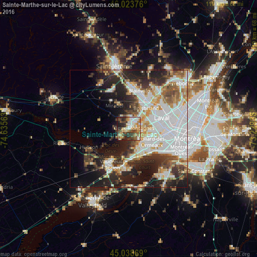
Analysis of Sainte-Marthe-sur-le-Lac night lights 2016
Square area 10x10 km:
 11.06%
90-99
13.94%80-89
6.06%70-79
10.45%60-69
7.73%50-59
10.91%40-49
8.64%30-39
11.36%20-29
15%10-19
4.85%0-9
0%Square area 50x50 km:
13.99%90-99
9.15%80-89
3.94%70-79
4.58%60-69
4.29%50-59
3.96%40-49
4.48%30-39
5.91%20-29
10.32%10-19
13.14%0-9
26.24%Clear (daylight) street map image can be seen on geolist.org.
Map coordinates:
46° 1' 25.5" North, 74° 38' 8.3" West
45° 32' 0.2" North, 73° 55' 57" West
45° 2' 19.3" North, 73° 13' 45.8" West
Some cities around Sainte-Marthe-sur-le-Lac sort by population:
• Dollard-Des Ormeaux
9.5 km =5.9 mi,  117°
117°
• Pointe-Claire
13 km =8.1 mi,  136°
136°
• Boisbriand
12.1 km =7.5 mi,  40°
40°
• Kirkland
10.6 km =6.6 mi,  150°
150°
• Beaconsfield
12.3 km =7.6 mi, 154°
• Deux-Montagnes
2.4 km =1.5 mi,  86°
86°
• Rosemère
15.2 km =9.4 mi, 43°
• Pointe-Calumet
4.5 km =2.8 mi,  215°
215°
6138032 (p: 11,311)
Sources (retrieved 2019-11-25):
» Earth at Night: Flat Maps 2012, 2016