Saint-Basile-le-Grand night lights from space
Night Light of Saint-Basile-le-Grand (Quebec) from space (Canada) Src. Average luminocity for 10x10km area is 50.7727% and for 50x50km: 38.4161%.
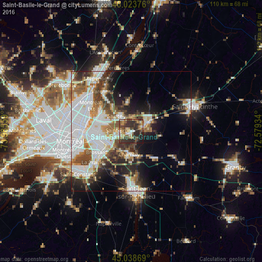
Analysis of Saint-Basile-le-Grand night lights 2016
Square area 10x10 km:
 4.39%
4.39%90-99
7.42%80-89
7.88%70-79
5.61%60-69
7.58%50-59
9.55%40-49
15.3%30-39
16.67%20-29
20.76%10-19
4.85%0-9
0%Square area 50x50 km:
11.51%90-99
8.93%80-89
2.91%70-79
3.61%60-69
3.78%50-59
4.27%40-49
5.54%30-39
5.21%20-29
7.73%10-19
8.98%0-9
37.54%Clear (daylight) street map image can be seen on geolist.org.
Map coordinates:
46° 1' 25.5" North, 73° 59' 8.1" West
45° 32' 0.2" North, 73° 16' 56.9" West
45° 2' 19.3" North, 72° 34' 45.6" West
Some cities around Saint-Basile-le-Grand sort by population:
• Boucherville
13.6 km =8.5 mi,  298°
298°
• Chambly
9.3 km =5.8 mi,  180°
180°
• Beloeil
7.1 km =4.4 mi,  56°
56°
• Mont-Saint-Hilaire
8.2 km =5.1 mi, 64°
• Otterburn Park
5.2 km =3.2 mi,  90°
90°
• Carignan
9.4 km =5.8 mi,  187°
187°
• Marieville
14.4 km =8.9 mi,  140°
140°
• Richelieu
10.4 km =6.5 mi,  164°
164°
6137489 (p: 15,605)
Sources (retrieved 2019-11-25):
» Earth at Night: Flat Maps 2012, 2016