Marieville night lights from space
Night Light of Marieville (Quebec) from space (Canada) Src. Average luminocity for 10x10km area is 15.0937% and for 50x50km: 25.1495%.
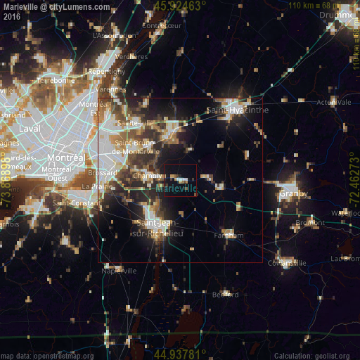
Analysis of Marieville night lights 2016
Square area 10x10 km:
 1.75%
1.75%90-99
1.43%80-89
1.27%70-79
2.54%60-69
0.63%50-59
0.95%40-49
1.59%30-39
2.54%20-29
2.54%10-19
17.3%0-9
67.46%Square area 50x50 km:
4.89%90-99
5.42%80-89
2.16%70-79
2.84%60-69
2.88%50-59
3.28%40-49
3.89%30-39
4.09%20-29
7.08%10-19
9.25%0-9
54.22%Clear (daylight) street map image can be seen on geolist.org.
Map coordinates:
45° 55' 28.7" North, 73° 52' 8.3" West
45° 26' 0.2" North, 73° 9' 57.1" West
44° 56' 16.1" North, 72° 27' 45.8" West
Some cities around Marieville sort by population:
• Saint-Jean-sur-Richelieu
15.9 km =9.9 mi,  208°
208°
• Chambly
9.3 km =5.8 mi,  281°
281°
• Beloeil
15.3 km =9.5 mi,  348°
348°
• Mont-Saint-Hilaire
14.7 km =9.1 mi, 353°
• Saint-Basile-le-Grand
14.4 km =8.9 mi,  320°
320°
• Otterburn Park
11.8 km =7.3 mi,  340°
340°
• Carignan
10.6 km =6.6 mi, 280°
• Richelieu
6.4 km =4 mi, 280°
6066350 (p: 5,600)
Sources (retrieved 2019-11-25):
» Earth at Night: Flat Maps 2012, 2016