Port-Cartier night lights from space
Night Light of Port-Cartier (Quebec) from space (Canada) Src. Average luminocity for 10x10km area is 13.6429% and for 50x50km: 0.6921%.
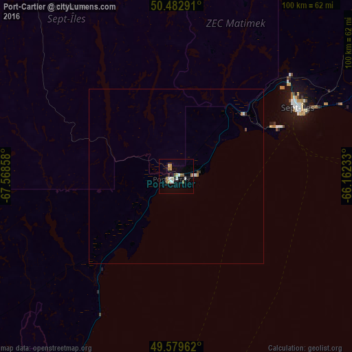
Analysis of Port-Cartier night lights 2016
Square area 10x10 km:
 2.52%
2.52%90-99
2.1%80-89
1.54%70-79
1.4%60-69
2.52%50-59
1.26%40-49
0.7%30-39
0.56%20-29
0.56%10-19
1.68%0-9
85.15%Square area 50x50 km:
0.11%90-99
0.12%80-89
0.06%70-79
0.1%60-69
0.1%50-59
0.07%40-49
0.05%30-39
0.05%20-29
0.03%10-19
0.07%0-9
99.24%Clear (daylight) street map image can be seen on geolist.org.
Map coordinates:
50° 28' 58.5" North, 67° 34' 6.9" West
50° 2' 0.2" North, 66° 51' 55.6" West
49° 34' 46.6" North, 66° 9' 44.4" West
Some cities around Port-Cartier sort by population:
• Rimouski
213.4 km =132.6 mi,  214°
214°
• Baie-Comeau
129.6 km =80.5 mi,  225°
225°
• Sept-Îles
39.1 km =24.3 mi,  61°
61°
• Matane
142.1 km =88.3 mi,  199°
199°
• Hauterive
136.9 km =85.1 mi, 227°
• Mont-Joli
187.7 km =116.6 mi, 210°
• Amqui
179.3 km =111.4 mi,  193°
193°
• Sainte-Anne-des-Monts
104.6 km =65 mi,  165°
165°
6111696 (p: 5,851)
Sources (retrieved 2019-11-25):
» Earth at Night: Flat Maps 2012, 2016