Nicolet night lights from space
Night Light of Nicolet (Quebec) from space (Canada) Src. Average luminocity for 10x10km area is 9.0923% and for 50x50km: 7.6018%.
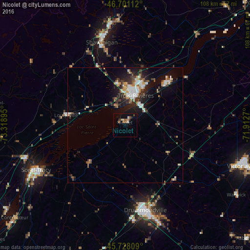
Analysis of Nicolet night lights 2016
Square area 10x10 km:
 0.28%
0.28%90-99
1.7%80-89
0.28%70-79
1.56%60-69
1.99%50-59
0.99%40-49
1.7%30-39
0.85%20-29
1.56%10-19
2.41%0-9
86.65%Square area 50x50 km:
1.12%90-99
1.51%80-89
0.45%70-79
0.83%60-69
0.97%50-59
0.82%40-49
1.08%30-39
1.39%20-29
2.27%10-19
4.83%0-9
84.74%Clear (daylight) street map image can be seen on geolist.org.
Map coordinates:
46° 42' 4" North, 73° 19' 8.2" West
46° 13' 0.3" North, 72° 36' 57" West
45° 43' 41.1" North, 71° 54' 45.7" West
Some cities around Nicolet sort by population:
• Trois-Rivières
15.2 km =9.4 mi,  20°
20°
• Drummondville
38.5 km =23.9 mi,  164°
164°
• Sorel-Tracy
43 km =26.7 mi,  243°
243°
• Shawinigan
40.2 km =25 mi,  345°
345°
• Victoriaville
53.4 km =33.2 mi,  110°
110°
• Sainte-Catherine
11.9 km =7.4 mi, 18°
• Bécancour
19.7 km =12.2 mi,  45°
45°
• Louiseville
25.4 km =15.8 mi,  279°
279°
6088132 (p: 5,669)
Sources (retrieved 2019-11-25):
» Earth at Night: Flat Maps 2012, 2016