Concord night lights from space
Night Light of Concord (Ontario) from space (Canada) Src. Average luminocity for 10x10km area is 98.9394% and for 50x50km: 64.6194%.
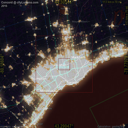
Analysis of Concord night lights 2016
Square area 10x10 km:
 62.88%
90-99
34.09%80-89
3.03%70-79
0%60-69
0%50-59
0%40-49
0%30-39
0%20-29
0%10-19
0%0-9
0%Square area 50x50 km:
30.61%90-99
18.54%80-89
3.99%70-79
3.2%60-69
3.38%50-59
3.43%40-49
4.04%30-39
3.91%20-29
6.14%10-19
7.54%0-9
15.24%Clear (daylight) street map image can be seen on geolist.org.
Map coordinates:
44° 18' 19.6" North, 80° 11' 9.7" West
43° 48' 0.4" North, 79° 28' 58.5" West
43° 17' 25.7" North, 78° 46' 47.2" West
Some cities around Concord sort by population:
• Toronto
12.3 km =7.6 mi,  154°
154°
• North York
6.5 km =4 mi,  124°
124°
• Scarborough
18.4 km =11.4 mi,  99°
99°
• Etobicoke
17.6 km =10.9 mi,  202°
202°
• Vaughan
4.2 km =2.6 mi,  342°
342°
• Richmond Hill
8.7 km =5.4 mi,  24°
24°
• East York
17.4 km =10.8 mi,  134°
134°
• Willowdale
7.7 km =4.8 mi, 118°
5926526 (p: 8,255)
Sources (retrieved 2019-11-25):
» Earth at Night: Flat Maps 2012, 2016