Baie-Saint-Paul night lights from space
Night Light of Baie-Saint-Paul (Quebec) from space (Canada) Src. Average luminocity for 10x10km area is 7.5938% and for 50x50km: 0.4861%.
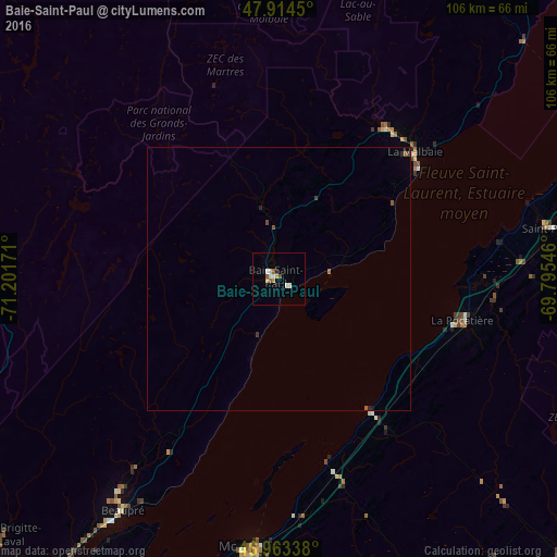
Analysis of Baie-Saint-Paul night lights 2016
Square area 10x10 km:
 0.57%
0.57%90-99
2.7%80-89
0.71%70-79
1.14%60-69
0.43%50-59
1.28%40-49
0.57%30-39
0%20-29
0.57%10-19
0%0-9
92.05%Square area 50x50 km:
0.02%90-99
0.11%80-89
0.03%70-79
0.05%60-69
0.05%50-59
0.12%40-49
0.09%30-39
0.03%20-29
0.09%10-19
0.03%0-9
99.38%Clear (daylight) street map image can be seen on geolist.org.
Map coordinates:
47° 54' 52.2" North, 71° 12' 6.2" West
47° 26' 27.9" North, 70° 29' 54.9" West
46° 57' 48.2" North, 69° 47' 43.7" West
Some cities around Baie-Saint-Paul sort by population:
• Québec
88.4 km =54.9 mi,  217°
217°
• Lévis
87.6 km =54.4 mi, 215°
• La Haute-Saint-Charles
90.1 km =56 mi,  227°
227°
• Rivière-du-Loup
83.5 km =51.9 mi,  59°
59°
• L'Ancienne-Lorette
96.7 km =60.1 mi, 221°
• Montmagny
51.4 km =31.9 mi,  184°
184°
• La Malbaie
35.1 km =21.8 mi,  47°
47°
• Saint-Henri
93.7 km =58.2 mi,  207°
207°
6690232 (p: 7,288)
Sources (retrieved 2019-11-25):
» Earth at Night: Flat Maps 2012, 2016