Sarpang night lights from space
Night Light of Sarpang (Geylegphug) from space (Bhutan) Src. Average luminocity for 10x10km area is 0.5813% and for 50x50km: 0.6174%.
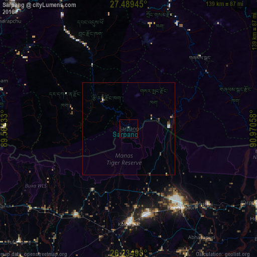
Analysis of Sarpang night lights 2016
Square area 10x10 km:
 0%
0%90-99
0%80-89
0%70-79
0%60-69
0%50-59
0.79%40-49
0%30-39
0%20-29
0%10-19
0%0-9
99.21%Square area 50x50 km:
0.06%90-99
0.11%80-89
0.04%70-79
0.03%60-69
0.07%50-59
0.16%40-49
0.17%30-39
0.09%20-29
0.21%10-19
0.09%0-9
98.96%Clear (daylight) street map image can be seen on geolist.org.
Map coordinates:
27° 29' 22" North, 89° 33' 51.6" East
26° 51' 50.2" North, 90° 16' 2.8" East
26° 14' 5.9" North, 90° 58' 14.1" East
Some cities around Sarpang sort by population:
• Bongaigaon, IN
51.8 km =32.2 mi,  146°
146°
• Kokrajhar, IN
51.5 km =32 mi,  179°
179°
• Tsirang
22.7 km =14.1 mi,  320°
320°
• Goshaingaon, IN
56.1 km =34.9 mi,  212°
212°
• Bijni, IN
59.6 km =37 mi,  133°
133°
• Bāsugaon, IN
46.6 km =29 mi,  161°
161°
• Daga
45.3 km =28.1 mi,  301°
301°
• Shemgang
55.1 km =34.2 mi,  44°
44°
1252460 (p: 10,416)
Sources (retrieved 2019-11-25):
» Earth at Night: Flat Maps 2012, 2016