Viseu night lights from space
Night Light of Viseu (Pará) from space (Brazil) Src. Average luminocity for 10x10km area is 5.9697% and for 50x50km: 0.8205%.
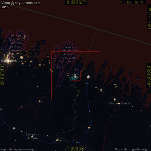
Analysis of Viseu night lights 2016
Square area 10x10 km:
 0%
0%90-99
0.87%80-89
2.38%70-79
1.08%60-69
0.87%50-59
0.87%40-49
0%30-39
0%20-29
0.87%10-19
0%0-9
93.07%Square area 50x50 km:
0%90-99
0.14%80-89
0.16%70-79
0.04%60-69
0.07%50-59
0.24%40-49
0.37%30-39
0.07%20-29
0.08%10-19
0%0-9
98.82%Clear (daylight) street map image can be seen on geolist.org.
Map coordinates:
0° 29' 37.1" South, 46° 50' 35.3" West
1° 11' 48" South, 46° 8' 24" West
1° 53' 58.3" South, 45° 26' 12.8" West
Some cities around Viseu sort by population:
• Bragança
71.3 km =44.3 mi,  282°
282°
• Capanema
115.7 km =71.9 mi,  270°
270°
• Augusto Corrêa
58.4 km =36.3 mi,  289°
289°
• Maracaçumé
96.2 km =59.8 mi,  167°
167°
• Carutapera
13.3 km =8.3 mi,  89°
89°
• Turiaçu
99.9 km =62.1 mi,  121°
121°
• Cândido Mendes
54.7 km =34 mi, 120°
• Ourém
115.3 km =71.6 mi,  249°
249°
3385022 (p: 18,958)
Sources (retrieved 2019-11-25):
» Earth at Night: Flat Maps 2012, 2016