Vicência night lights from space
Night Light of Vicência (Pernambuco) from space (Brazil) Src. Average luminocity for 10x10km area is 6.8946% and for 50x50km: 8.1939%.
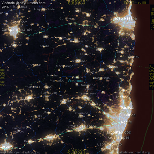
Analysis of Vicência night lights 2016
Square area 10x10 km:
 0%
0%90-99
0.21%80-89
0.62%70-79
0.83%60-69
2.48%50-59
1.65%40-49
0%30-39
3.31%20-29
2.27%10-19
1.03%0-9
87.6%Square area 50x50 km:
0.22%90-99
0.69%80-89
1.75%70-79
0.66%60-69
1.23%50-59
1.46%40-49
1.34%30-39
0.98%20-29
1.91%10-19
4.87%0-9
84.88%Clear (daylight) street map image can be seen on geolist.org.
Map coordinates:
6° 57' 34.3" South, 36° 1' 47.3" West
7° 39' 25" South, 35° 19' 36" West
8° 21' 11.6" South, 34° 37' 24.8" West
Some cities around Vicência sort by population:
• Carpina
23 km =14.3 mi,  159°
159°
• Timbaúba
16.9 km =10.5 mi,  3°
3°
• Limoeiro
27.8 km =17.3 mi,  209°
209°
• Nazaré da Mata
14.4 km =8.9 mi,  130°
130°
• Condado
25.6 km =15.9 mi,  72°
72°
• Macaparana
18 km =11.2 mi,  309°
309°
• Araçoiaba
29.9 km =18.6 mi,  119°
119°
• Itaquitinga
24.8 km =15.4 mi,  92°
92°
3385118 (p: 10,378)
Sources (retrieved 2019-11-25):
» Earth at Night: Flat Maps 2012, 2016