Tocantins night lights from space
Night Light of Tocantins (Minas Gerais) from space (Brazil) Src. Average luminocity for 10x10km area is 15.248% and for 50x50km: 7.1895%.
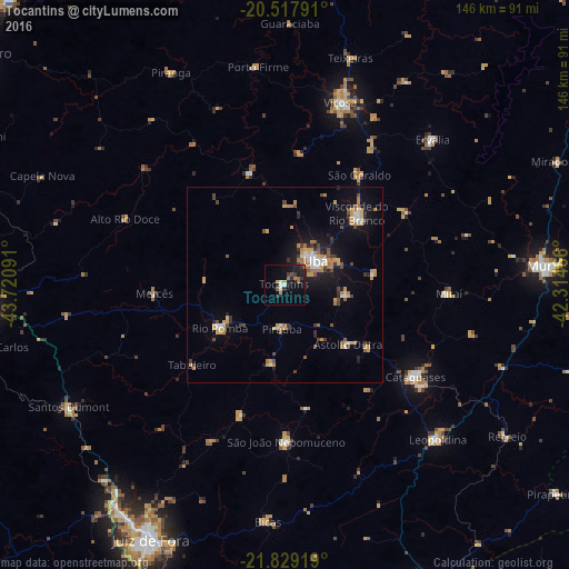
Analysis of Tocantins night lights 2016
Square area 10x10 km:
 1.39%
1.39%90-99
1.79%80-89
0.79%70-79
1.98%60-69
2.58%50-59
1.39%40-49
1.39%30-39
3.57%20-29
4.76%10-19
14.88%0-9
65.48%Square area 50x50 km:
0.78%90-99
0.58%80-89
0.66%70-79
1.54%60-69
1.31%50-59
0.59%40-49
1.05%30-39
1.08%20-29
1.04%10-19
4.88%0-9
86.49%Clear (daylight) street map image can be seen on geolist.org.
Map coordinates:
20° 31' 4.5" South, 43° 43' 15.3" West
21° 10' 30" South, 43° 1' 4" West
21° 49' 45.1" South, 42° 18' 52.8" West
Some cities around Tocantins sort by population:
• Ubá
9.9 km =6.2 mi,  51°
51°
• Cataguases
40.9 km =25.4 mi,  125°
125°
• Visconde do Rio Branco
26 km =16.2 mi, 45°
• São João Nepomuceno
40.6 km =25.2 mi,  178°
178°
• Rio Pomba
20.1 km =12.5 mi,  236°
236°
• Astolfo Dutra
22.4 km =13.9 mi, 134°
• Miraí
41.9 km =26 mi,  93°
93°
• Rio Novo
35.4 km =22 mi,  198°
198°
3446392 (p: 12,875)
Sources (retrieved 2019-11-25):
» Earth at Night: Flat Maps 2012, 2016