Astolfo Dutra night lights from space
Night Light of Astolfo Dutra (Minas Gerais) from space (Brazil) Src. Average luminocity for 10x10km area is 8.2443% and for 50x50km: 6.97%.
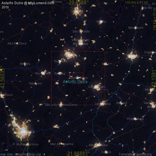
Analysis of Astolfo Dutra night lights 2016
Square area 10x10 km:
 0.57%
0.57%90-99
0.95%80-89
0.38%70-79
1.89%60-69
1.52%50-59
1.7%40-49
1.14%30-39
1.33%20-29
1.14%10-19
0.57%0-9
88.83%Square area 50x50 km:
0.9%90-99
0.76%80-89
0.54%70-79
1.4%60-69
1.43%50-59
0.52%40-49
0.89%30-39
0.99%20-29
0.97%10-19
4.14%0-9
87.44%Clear (daylight) street map image can be seen on geolist.org.
Map coordinates:
20° 39' 31.7" South, 43° 33' 55.3" West
21° 18' 55" South, 42° 51' 44" West
21° 58' 7.8" South, 42° 9' 32.8" West
Some cities around Astolfo Dutra sort by population:
• Ubá
23.3 km =14.5 mi,  338°
338°
• Cataguases
19 km =11.8 mi,  115°
115°
• Leopoldina
33.1 km =20.6 mi,  136°
136°
• São João Nepomuceno
29.3 km =18.2 mi,  211°
211°
• Rio Pomba
33.1 km =20.6 mi,  277°
277°
• Tocantins
22.4 km =13.9 mi,  314°
314°
• Miraí
29 km =18 mi,  62°
62°
• Rio Novo
32.7 km =20.3 mi,  236°
236°
3471369 (p: 10,999)
Sources (retrieved 2019-11-25):
» Earth at Night: Flat Maps 2012, 2016