São João do Paraíso night lights from space
Night Light of São João do Paraíso (Minas Gerais) from space (Brazil) Src. Average luminocity for 10x10km area is 4.8822% and for 50x50km: 0.3101%.
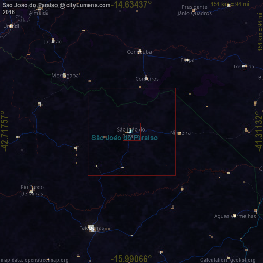
Analysis of São João do Paraíso night lights 2016
Square area 10x10 km:
 1.24%
1.24%90-99
2.07%80-89
0%70-79
0%60-69
0%50-59
1.65%40-49
0%30-39
0%20-29
0%10-19
0.83%0-9
94.21%Square area 50x50 km:
0.05%90-99
0.08%80-89
0.07%70-79
0%60-69
0%50-59
0.1%40-49
0.03%30-39
0.01%20-29
0.02%10-19
0.03%0-9
99.6%Clear (daylight) street map image can be seen on geolist.org.
Map coordinates:
14° 38' 3.7" South, 42° 43' 3.3" West
15° 18' 49" South, 42° 0' 52" West
15° 59' 26.4" South, 41° 18' 40.8" West
Some cities around São João do Paraíso sort by population:
• Taiobeiras
59.7 km =37.1 mi,  203°
203°
• Espinosa
96.5 km =60 mi,  296°
296°
• Águas Vermelhas
76.5 km =47.5 mi,  129°
129°
• Caculé
92.8 km =57.7 mi,  346°
346°
• Monte Azul
94 km =58.4 mi,  280°
280°
• São Felipe
85.2 km =52.9 mi,  51°
51°
• Rio Pardo de Minas
65.2 km =40.5 mi,  239°
239°
• Mato Verde
91.8 km =57 mi,  264°
264°
3448861 (p: 8,859)
Sources (retrieved 2019-11-25):
» Earth at Night: Flat Maps 2012, 2016