São Francisco de Paula night lights from space
Night Light of São Francisco de Paula (Rio Grande do Sul) from space (Brazil) Src. Average luminocity for 10x10km area is 14.3636% and for 50x50km: 5.9348%.
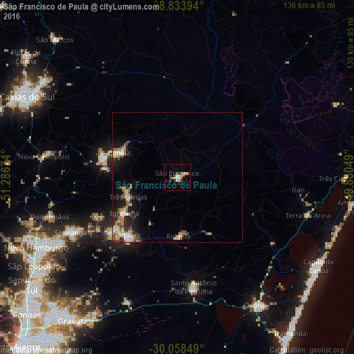
Analysis of São Francisco de Paula night lights 2016
Square area 10x10 km:
 1.52%
1.52%90-99
1.52%80-89
2.27%70-79
3.79%60-69
1.52%50-59
1.33%40-49
3.22%30-39
0.76%20-29
0%10-19
0.76%0-9
83.33%Square area 50x50 km:
0.6%90-99
0.77%80-89
0.81%70-79
1.05%60-69
0.81%50-59
0.98%40-49
0.9%30-39
0.74%20-29
1.29%10-19
3.76%0-9
88.31%Clear (daylight) street map image can be seen on geolist.org.
Map coordinates:
28° 50' 2.2" South, 51° 17' 12.3" West
29° 26' 53" South, 50° 35' 1" West
30° 3' 30.6" South, 49° 52' 49.8" West
Some cities around São Francisco de Paula sort by population:
• Sapiranga
46.1 km =28.6 mi,  242°
242°
• Parobé
31.5 km =19.6 mi,  230°
230°
• Taquara
29.5 km =18.3 mi,  220°
220°
• Canela
24.5 km =15.2 mi,  294°
294°
• Igrejinha
24.4 km =15.2 mi, 234°
• Três Coroas
20.3 km =12.6 mi,  247°
247°
• Nova Petrópolis
52 km =32.3 mi,  278°
278°
• Rolante
22.5 km =14 mi,  178°
178°
3449121 (p: 13,292)
Sources (retrieved 2019-11-25):
» Earth at Night: Flat Maps 2012, 2016