Nova Era night lights from space
Night Light of Nova Era (Minas Gerais) from space (Brazil) Src. Average luminocity for 10x10km area is 11.9752% and for 50x50km: 6.8653%.
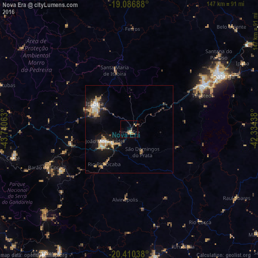
Analysis of Nova Era night lights 2016
Square area 10x10 km:
 0.62%
0.62%90-99
0.21%80-89
1.24%70-79
7.23%60-69
1.03%50-59
0%40-49
2.48%30-39
0.83%20-29
0.83%10-19
0%0-9
85.54%Square area 50x50 km:
0.67%90-99
0.77%80-89
0.73%70-79
1.88%60-69
0.89%50-59
0.44%40-49
1.13%30-39
0.78%20-29
1.33%10-19
5.47%0-9
85.9%Clear (daylight) street map image can be seen on geolist.org.
Map coordinates:
19° 5' 12.8" South, 43° 44' 26.3" West
19° 45' 0" South, 43° 2' 15" West
20° 24' 37.4" South, 42° 20' 3.8" West
Some cities around Nova Era sort by population:
• Coronel Fabriciano
49.9 km =31 mi,  58°
58°
• Itabira
24.6 km =15.3 mi,  306°
306°
• Timóteo
44.8 km =27.8 mi,  65°
65°
• João Monlevade
15.7 km =9.8 mi,  244°
244°
• Barão de Cocais
51.8 km =32.2 mi,  245°
245°
• Alvinópolis
39.7 km =24.7 mi,  181°
181°
• Rio Piracicaba
24.5 km =15.2 mi,  215°
215°
• São Domingos do Prata
14.7 km =9.1 mi,  150°
150°
3456176 (p: 15,595)
Sources (retrieved 2019-11-25):
» Earth at Night: Flat Maps 2012, 2016