Pôrto Barra do Ivinheima night lights from space
Night Light of Pôrto Barra do Ivinheima (Mato Grosso do Sul) from space (Brazil) Src. Average luminocity for 10x10km area is 0.0496% and for 50x50km: 0.3534%.
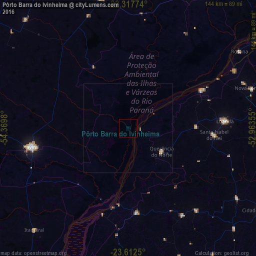
Analysis of Pôrto Barra do Ivinheima night lights 2016
Square area 10x10 km:
 0%
0%90-99
0%80-89
0%70-79
0%60-69
0%50-59
0%40-49
0%30-39
0%20-29
0%10-19
0%0-9
100%Square area 50x50 km:
0.02%90-99
0.07%80-89
0.06%70-79
0.03%60-69
0.06%50-59
0.02%40-49
0.06%30-39
0.07%20-29
0.06%10-19
0.03%0-9
99.5%Clear (daylight) street map image can be seen on geolist.org.
Map coordinates:
22° 19' 3.9" South, 54° 22' 11.3" West
22° 58' 0" South, 53° 40' 0" West
23° 36' 45" South, 52° 57' 48.8" West
Some cities around Pôrto Barra do Ivinheima sort by population:
• Umuarama
95.5 km =59.3 mi,  158°
158°
• Naviraí
54.7 km =34 mi,  258°
258°
• Loanda
54.4 km =33.8 mi,  84°
84°
• Cruzeiro do Oeste
109.3 km =67.9 mi,  146°
146°
• Altãnia
103.7 km =64.4 mi,  193°
193°
• Nova Londrina
73.3 km =45.5 mi,  72°
72°
• Eldorado
110.8 km =68.8 mi,  214°
214°
• Bataiporã
85 km =52.8 mi,  28°
28°
3452909 (p: 14,527)
Sources (retrieved 2019-11-25):
» Earth at Night: Flat Maps 2012, 2016