Loanda night lights from space
Night Light of Loanda (Paraná) from space (Brazil) Src. Average luminocity for 10x10km area is 17.1825% and for 50x50km: 2.6642%.
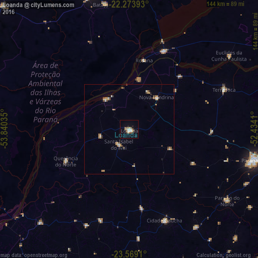
Analysis of Loanda night lights 2016
Square area 10x10 km:
 3.57%
3.57%90-99
1.19%80-89
3.37%70-79
0.6%60-69
3.77%50-59
1.39%40-49
1.19%30-39
1.59%20-29
2.78%10-19
4.37%0-9
76.19%Square area 50x50 km:
0.33%90-99
0.25%80-89
0.51%70-79
0.28%60-69
0.63%50-59
0.1%40-49
0.43%30-39
0.27%20-29
0.32%10-19
0.28%0-9
96.61%Clear (daylight) street map image can be seen on geolist.org.
Map coordinates:
22° 16' 26.1" South, 53° 50' 25.3" West
22° 55' 23" South, 53° 8' 14" West
23° 34' 8.8" South, 52° 26' 2.8" West
Some cities around Loanda sort by population:
• Paranavaí
70.8 km =44 mi,  103°
103°
• Pôrto Barra do Ivinheima
54.4 km =33.8 mi,  264°
264°
• Nova Londrina
23.4 km =14.5 mi,  41°
41°
• Alto Paraná
86.8 km =53.9 mi,  105°
105°
• Tapejara
94 km =58.4 mi,  163°
163°
• Terra Rica
58.4 km =36.3 mi,  65°
65°
• Nova Aurora
58.8 km =36.5 mi,  83°
83°
• Bataiporã
71.1 km =44.2 mi,  348°
348°
3458479 (p: 18,233)
Sources (retrieved 2019-11-25):
» Earth at Night: Flat Maps 2012, 2016