Orobó night lights from space
Night Light of Orobó (Pernambuco) from space (Brazil) Src. Average luminocity for 10x10km area is 9.5413% and for 50x50km: 7.2624%.
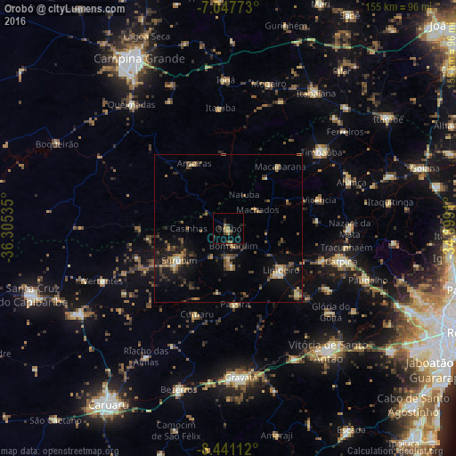
Analysis of Orobó night lights 2016
Square area 10x10 km:
 0%
0%90-99
0%80-89
0.83%70-79
0.83%60-69
2.48%50-59
2.48%40-49
1.45%30-39
3.72%20-29
2.69%10-19
1.45%0-9
84.09%Square area 50x50 km:
0.15%90-99
0.47%80-89
0.8%70-79
0.61%60-69
1.22%50-59
1.72%40-49
1.43%30-39
1.67%20-29
2.19%10-19
5.74%0-9
84.01%Clear (daylight) street map image can be seen on geolist.org.
Map coordinates:
7° 2' 51.8" South, 36° 18' 19.3" West
7° 44' 42" South, 35° 36' 8" West
8° 26' 28" South, 34° 53' 56.8" West
Some cities around Orobó sort by population:
• Limoeiro
22.1 km =13.7 mi,  130°
130°
• Surubim
19.4 km =12.1 mi,  239°
239°
• Macaparana
26.8 km =16.7 mi,  37°
37°
• Bom Jardim
5.9 km =3.7 mi,  163°
163°
• Passira
27.9 km =17.3 mi,  175°
175°
• João Alfredo
12.4 km =7.7 mi,  172°
172°
• Aroeiras
25.1 km =15.6 mi,  332°
332°
• Cumaru
30.9 km =19.2 mi,  199°
199°
3393470 (p: 5,884)
Sources (retrieved 2019-11-25):
» Earth at Night: Flat Maps 2012, 2016