Aroeiras night lights from space
Night Light of Aroeiras (Paraíba) from space (Brazil) Src. Average luminocity for 10x10km area is 6.4004% and for 50x50km: 2.8817%.
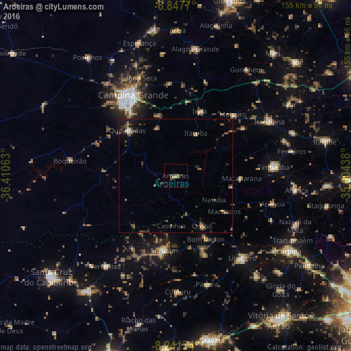
Analysis of Aroeiras night lights 2016
Square area 10x10 km:
 0%
0%90-99
0%80-89
1.73%70-79
0%60-69
1.73%50-59
0.22%40-49
3.25%30-39
2.16%20-29
1.52%10-19
1.3%0-9
88.1%Square area 50x50 km:
0.03%90-99
0.13%80-89
0.23%70-79
0.19%60-69
0.55%50-59
0.73%40-49
0.75%30-39
0.73%20-29
0.98%10-19
1.73%0-9
93.93%Clear (daylight) street map image can be seen on geolist.org.
Map coordinates:
6° 50' 51.7" South, 36° 24' 38.3" West
7° 32' 43" South, 35° 42' 27" West
8° 14' 30.3" South, 35° 0' 15.8" West
Some cities around Aroeiras sort by population:
• Campina Grande
39.9 km =24.8 mi,  331°
331°
• Surubim
32.4 km =20.1 mi,  189°
189°
• Macaparana
28.1 km =17.5 mi,  92°
92°
• Bom Jardim
30.9 km =19.2 mi,  154°
154°
• João Alfredo
36.9 km =22.9 mi,  159°
159°
• Ingá
31.5 km =19.6 mi,  21°
21°
• Orobó
25.1 km =15.6 mi, 152°
• Fagundes
22.4 km =13.9 mi,  340°
340°
3407091 (p: 7,019)
Sources (retrieved 2019-11-25):
» Earth at Night: Flat Maps 2012, 2016