Cumaru night lights from space
Night Light of Cumaru (Pernambuco) from space (Brazil) Src. Average luminocity for 10x10km area is 11.0558% and for 50x50km: 11.2955%.
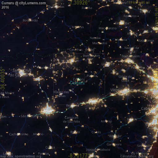
Analysis of Cumaru night lights 2016
Square area 10x10 km:
 0%
0%90-99
0.41%80-89
1.65%70-79
2.48%60-69
0.62%50-59
2.69%40-49
2.07%30-39
4.55%20-29
1.65%10-19
0.62%0-9
83.26%Square area 50x50 km:
0.32%90-99
0.98%80-89
1.2%70-79
0.96%60-69
1.86%50-59
2.52%40-49
2.39%30-39
2.73%20-29
3.57%10-19
8.12%0-9
75.35%Clear (daylight) street map image can be seen on geolist.org.
Map coordinates:
7° 18' 33.3" South, 36° 24' 1.3" West
8° 0' 22" South, 35° 41' 50" West
8° 42' 6.4" South, 34° 59' 38.8" West
Some cities around Cumaru sort by population:
• Gravatá
26.1 km =16.2 mi,  146°
146°
• Bezerros
27.5 km =17.1 mi,  203°
203°
• Limoeiro
30.9 km =19.2 mi,  61°
61°
• Surubim
20.3 km =12.6 mi,  341°
341°
• Bom Jardim
26.3 km =16.3 mi,  27°
27°
• Passira
12.9 km =8 mi,  84°
84°
• João Alfredo
20.6 km =12.8 mi,  35°
35°
• Orobó
30.9 km =19.2 mi,  19°
19°
3401404 (p: 6,861)
Sources (retrieved 2019-11-25):
» Earth at Night: Flat Maps 2012, 2016