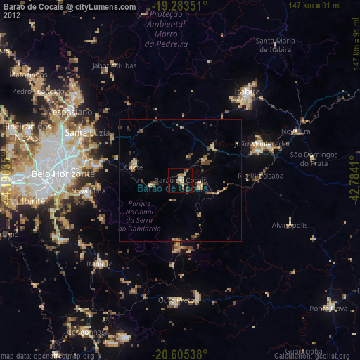
Barão de Cocais night lights from space
Night Light of Barão de Cocais (Minas Gerais) from space (Brazil) Src. Average luminocity for 10x10km area is 23.8485% and for 50x50km: 4.5601%.

Analysis of Barão de Cocais night lights 2016
Square area 10x10 km:
 0.43%
0.43%90-99
0.43%80-89
1.73%70-79
8.23%60-69
7.14%50-59
2.16%40-49
4.76%30-39
5.41%20-29
0.87%10-19
19.26%0-9
49.57%Square area 50x50 km:
0.08%90-99
0.18%80-89
0.39%70-79
1.18%60-69
0.8%50-59
0.45%40-49
1.23%30-39
0.75%20-29
0.67%10-19
2.04%0-9
92.21%Clear (daylight) street map image can be seen on geolist.org.
Map coordinates:
19° 17' 0.6" South, 44° 11' 25.3" West
19° 56' 45" South, 43° 29' 14" West
20° 36' 19.4" South, 42° 47' 2.8" West
Some cities around Barão de Cocais sort by population:
• Belo Horizonte
47.2 km =29.3 mi,  273°
273°
• Santa Luzia
42.8 km =26.6 mi,  297°
297°
• Itabira
45.4 km =28.2 mi,  36°
36°
• Nova Lima
37.8 km =23.5 mi,  263°
263°
• João Monlevade
36.1 km =22.4 mi,  65°
65°
• Caeté
20.4 km =12.7 mi,  290°
290°
• Raposos
33.2 km =20.6 mi, 265°
• Rio Piracicaba
32.8 km =20.4 mi,  86°
86°
3470878 (p: 22,387)
Sources (retrieved 2019-11-25):
» Earth at Night: Flat Maps 2012, 2016