Maragogi night lights from space
Night Light of Maragogi (Alagoas) from space (Brazil) Src. Average luminocity for 10x10km area is 17.5736% and for 50x50km: 4.0739%.
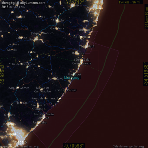
Analysis of Maragogi night lights 2016
Square area 10x10 km:
 1.3%
1.3%90-99
3.03%80-89
2.38%70-79
1.95%60-69
2.6%50-59
1.3%40-49
3.03%30-39
3.46%20-29
2.81%10-19
3.9%0-9
74.24%Square area 50x50 km:
0.14%90-99
0.56%80-89
0.56%70-79
0.56%60-69
0.71%50-59
0.49%40-49
0.49%30-39
0.71%20-29
0.57%10-19
2.18%0-9
93.02%Clear (daylight) street map image can be seen on geolist.org.
Map coordinates:
8° 19' 1.6" South, 35° 55' 32.3" West
9° 0' 44" South, 35° 13' 21" West
9° 42' 21.5" South, 34° 31' 9.8" West
Some cities around Maragogi sort by population:
• Barreiros
21.9 km =13.6 mi,  10°
10°
• Matriz de Camaragibe
37.5 km =23.3 mi,  245°
245°
• Tamandaré
31.5 km =19.6 mi,  25°
25°
• Porto Calvo
19.6 km =12.2 mi,  259°
259°
• Água Preta
47.9 km =29.8 mi,  315°
315°
• Rio Formoso
38.7 km =24 mi, 9°
• São José da Coroa Grande
15.1 km =9.4 mi, 32°
• Novo Lino
47.8 km =29.7 mi,  283°
283°
3395458 (p: 16,066)
Sources (retrieved 2019-11-25):
» Earth at Night: Flat Maps 2012, 2016