Barra de Santo Antônio night lights from space
Night Light of Barra de Santo Antônio (Alagoas) from space (Brazil) Src. Average luminocity for 10x10km area is 15.961% and for 50x50km: 6.5616%.
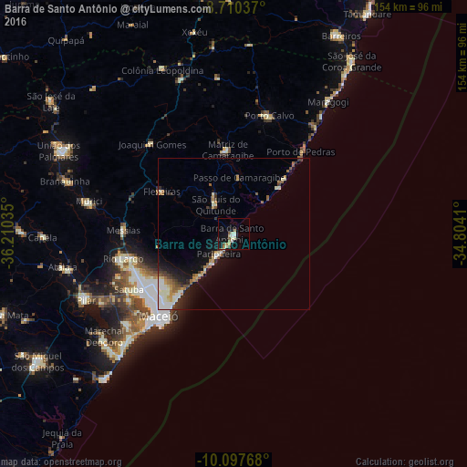
Analysis of Barra de Santo Antônio night lights 2016
Square area 10x10 km:
 0.65%
0.65%90-99
5.84%80-89
1.3%70-79
1.95%60-69
1.52%50-59
3.25%40-49
1.08%30-39
0%20-29
0%10-19
10.39%0-9
74.03%Square area 50x50 km:
0.65%90-99
1.91%80-89
0.48%70-79
0.84%60-69
0.92%50-59
0.87%40-49
0.49%30-39
0.82%20-29
1.01%10-19
4.04%0-9
87.97%Clear (daylight) street map image can be seen on geolist.org.
Map coordinates:
8° 42' 37.3" South, 36° 12' 37.3" West
9° 24' 17" South, 35° 30' 26" West
10° 5' 51.6" South, 34° 48' 14.8" West
Some cities around Barra de Santo Antônio sort by population:
• Maceió
38.3 km =23.8 mi,  220°
220°
• Rio Largo
38.8 km =24.1 mi,  257°
257°
• São Luís do Quitunde
11.3 km =7 mi,  328°
328°
• Matriz de Camaragibe
28.3 km =17.6 mi,  354°
354°
• Porto Calvo
41.7 km =25.9 mi,  16°
16°
• Satuba
39 km =24.2 mi,  243°
243°
• Messias
36.8 km =22.9 mi,  273°
273°
• Flexeiras
37.8 km =23.5 mi,  307°
307°
3406333 (p: 10,057)
Sources (retrieved 2019-11-25):
» Earth at Night: Flat Maps 2012, 2016