Junqueirópolis night lights from space
Night Light of Junqueirópolis (São Paulo) from space (Brazil) Src. Average luminocity for 10x10km area is 13.0265% and for 50x50km: 3.1437%.
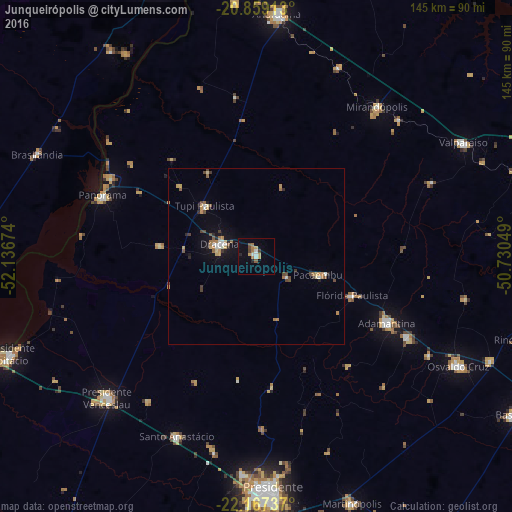
Analysis of Junqueirópolis night lights 2016
Square area 10x10 km:
 2.08%
2.08%90-99
0.95%80-89
0.95%70-79
2.46%60-69
2.65%50-59
1.52%40-49
1.52%30-39
0.76%20-29
1.52%10-19
0.95%0-9
84.66%Square area 50x50 km:
0.34%90-99
0.26%80-89
0.34%70-79
0.54%60-69
0.56%50-59
0.37%40-49
0.5%30-39
0.31%20-29
0.38%10-19
1.43%0-9
94.96%Clear (daylight) street map image can be seen on geolist.org.
Map coordinates:
20° 51' 32.9" South, 52° 8' 12.3" West
21° 30' 53" South, 51° 26' 1" West
22° 10' 2.5" South, 50° 43' 49.8" West
Some cities around Junqueirópolis sort by population:
• Adamantina
41.9 km =26 mi,  116°
116°
• Mirandopólis
54.6 km =33.9 mi,  39°
39°
• Santo Anastácio
40.3 km =25 mi,  206°
206°
• Lucélia
48.6 km =30.2 mi, 118°
• Panorama
47.5 km =29.5 mi,  291°
291°
• Tupi Paulista
20.5 km =12.7 mi,  316°
316°
• Pacaembu
18.7 km =11.6 mi,  106°
106°
• Paulista Flórida
26 km =16.2 mi, 111°
3459452 (p: 13,965)
Sources (retrieved 2019-11-25):
» Earth at Night: Flat Maps 2012, 2016