Jacutinga night lights from space
Night Light of Jacutinga (Minas Gerais) from space (Brazil) Src. Average luminocity for 10x10km area is 12.0379% and for 50x50km: 7.5752%.
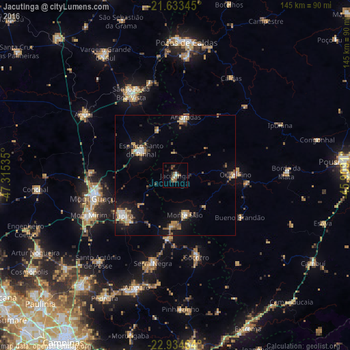
Analysis of Jacutinga night lights 2016
Square area 10x10 km:
 0.38%
0.38%90-99
1.89%80-89
0.19%70-79
1.33%60-69
1.7%50-59
3.6%40-49
3.22%30-39
2.84%20-29
2.65%10-19
1.14%0-9
81.06%Square area 50x50 km:
0.6%90-99
0.87%80-89
0.94%70-79
1.29%60-69
1.11%50-59
1.14%40-49
0.99%30-39
1.14%20-29
0.92%10-19
5.8%0-9
85.21%Clear (daylight) street map image can be seen on geolist.org.
Map coordinates:
21° 38' 0.4" South, 47° 18' 55.3" West
22° 17' 8" South, 46° 36' 44" West
22° 56' 4.7" South, 45° 54' 32.8" West
Some cities around Jacutinga sort by population:
• Mogi Guaçu
35.5 km =22.1 mi,  255°
255°
• Itapira
27.3 km =17 mi,  232°
232°
• Espírito Santo do Pinhal
20.2 km =12.6 mi,  338°
338°
• Andradas
24.6 km =15.3 mi,  10°
10°
• Socorro
35.1 km =21.8 mi,  165°
165°
• Águas de Lindóia
21.3 km =13.2 mi,  185°
185°
• Monte Sião
16.8 km =10.4 mi, 165°
• Bueno Brandão
31.9 km =19.8 mi,  122°
122°
3460267 (p: 18,469)
Sources (retrieved 2019-11-25):
» Earth at Night: Flat Maps 2012, 2016