Ituberá night lights from space
Night Light of Ituberá (Bahia) from space (Brazil) Src. Average luminocity for 10x10km area is 7.2872% and for 50x50km: 1.4702%.
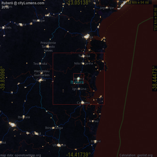
Analysis of Ituberá night lights 2016
Square area 10x10 km:
 0%
0%90-99
2.27%80-89
0.41%70-79
1.24%60-69
0.83%50-59
2.27%40-49
1.24%30-39
0%20-29
0.83%10-19
1.65%0-9
89.26%Square area 50x50 km:
0.02%90-99
0.19%80-89
0.27%70-79
0.12%60-69
0.41%50-59
0.28%40-49
0.26%30-39
0.22%20-29
0.39%10-19
0.14%0-9
97.69%Clear (daylight) street map image can be seen on geolist.org.
Map coordinates:
13° 3' 5" South, 39° 51' 3.5" West
13° 44' 7.4" South, 39° 8' 52.3" West
14° 25' 2.6" South, 38° 26' 41" West
Some cities around Ituberá sort by population:
• Valença
41.4 km =25.7 mi,  11°
11°
• Gandu
36.6 km =22.7 mi,  268°
268°
• Ibirataia
64.7 km =40.2 mi,  235°
235°
• Ubatã
66.7 km =41.4 mi,  217°
217°
• Camamu
23.8 km =14.8 mi,  168°
168°
• Itacaré
62.6 km =38.9 mi,  164°
164°
• Taperoá
22.6 km =14 mi, 13°
• Ibirapitanga
53.5 km =33.2 mi,  207°
207°
3460530 (p: 19,887)
Sources (retrieved 2019-11-25):
» Earth at Night: Flat Maps 2012, 2016