Itaí night lights from space
Night Light of Itaí (São Paulo) from space (Brazil) Src. Average luminocity for 10x10km area is 13.4678% and for 50x50km: 2.2953%.
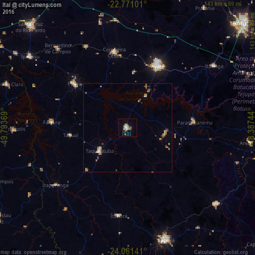

Analysis of Itaí night lights 2016
Square area 10x10 km:
 1.7%
1.7%90-99
2.08%80-89
0.38%70-79
1.89%60-69
2.08%50-59
3.22%40-49
3.03%30-39
1.52%20-29
0%10-19
0.76%0-9
83.33%Square area 50x50 km:
0.16%90-99
0.16%80-89
0.21%70-79
0.55%60-69
0.43%50-59
0.44%40-49
0.35%30-39
0.33%20-29
0.15%10-19
0.33%0-9
96.88%Clear (daylight) street map image can be seen on geolist.org.
Map coordinates:
22° 46' 15.6" South, 49° 47' 37.3" West
23° 25' 4" South, 49° 5' 26" West
24° 3' 41.1" South, 48° 23' 14.8" West
Some cities around Itaí sort by population:
• Avaré
39.3 km =24.4 mi,  25°
25°
• Piraju
39 km =24.2 mi,  309°
309°
• Taquarituba
20.3 km =12.6 mi,  230°
230°
• Paranapanema
37.5 km =23.3 mi,  84°
84°
• Cerqueira César
43.2 km =26.8 mi,  349°
349°
• Fartura
42.9 km =26.7 mi,  274°
274°
• Itaberá
49.6 km =30.8 mi,  185°
185°
• Itaporanga
51.9 km =32.2 mi, 231°
3460887 (p: 22,304)
Sources (retrieved 2019-11-25):
» Earth at Night: Flat Maps 2012, 2016