Itapemirim night lights from space
Night Light of Itapemirim (Espírito Santo) from space (Brazil) Src. Average luminocity for 10x10km area is 30.6845% and for 50x50km: 10.2729%.
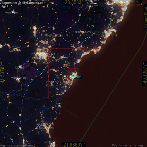
Analysis of Itapemirim night lights 2016
Square area 10x10 km:
 4.37%
4.37%90-99
6.55%80-89
2.58%70-79
5.56%60-69
1.59%50-59
1.98%40-49
4.76%30-39
5.75%20-29
4.96%10-19
34.13%0-9
27.78%Square area 50x50 km:
0.47%90-99
0.73%80-89
0.77%70-79
1.79%60-69
1.44%50-59
1.65%40-49
2.73%30-39
1.8%20-29
1.73%10-19
10.22%0-9
76.66%Clear (daylight) street map image can be seen on geolist.org.
Map coordinates:
20° 21' 11.9" South, 41° 32' 13.3" West
21° 0' 40" South, 40° 50' 2" West
21° 39' 57.7" South, 40° 7' 50.8" West
Some cities around Itapemirim sort by population:
• Cachoeiro de Itapemirim
34.1 km =21.2 mi,  301°
301°
• Guarapari
51.1 km =31.8 mi,  42°
42°
• Marataizes
3.7 km =2.3 mi,  164°
164°
• Piúma
22.5 km =14 mi,  31°
31°
• Mimoso do Sul
55.6 km =34.5 mi,  263°
263°
• Rio Novo do Sul
19.7 km =12.2 mi,  327°
327°
• Alfredo Chaves
42.7 km =26.5 mi,  11°
11°
• Iconha
24.4 km =15.2 mi, 5°
3460738 (p: 17,536)
Sources (retrieved 2019-11-25):
» Earth at Night: Flat Maps 2012, 2016