Itacarambi night lights from space
Night Light of Itacarambi (Minas Gerais) from space (Brazil) Src. Average luminocity for 10x10km area is 6.5744% and for 50x50km: 0.5837%.
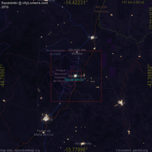
Analysis of Itacarambi night lights 2016
Square area 10x10 km:
 1.24%
1.24%90-99
1.24%80-89
0.83%70-79
0.83%60-69
0%50-59
0.41%40-49
0.83%30-39
1.24%20-29
2.48%10-19
0.83%0-9
90.08%Square area 50x50 km:
0.07%90-99
0.07%80-89
0.07%70-79
0.07%60-69
0.03%50-59
0.1%40-49
0.17%30-39
0.19%20-29
0.16%10-19
0.1%0-9
98.98%Clear (daylight) street map image can be seen on geolist.org.
Map coordinates:
14° 25' 20.3" South, 44° 47' 42.3" West
15° 6' 8" South, 44° 5' 31" West
15° 46' 47.9" South, 43° 23' 19.8" West
Some cities around Itacarambi sort by population:
• Janaúba
114.5 km =71.1 mi,  132°
132°
• Januária
51.7 km =32.1 mi,  213°
213°
• São Francisco
125.3 km =77.9 mi,  221°
221°
• Barreiro do Jaíba
78.3 km =48.7 mi,  136°
136°
• Manga
42.2 km =26.2 mi,  24°
24°
• Carinhanha
95.4 km =59.3 mi, 21°
• São João da Ponte
92.4 km =57.4 mi,  174°
174°
• Varzelândia
67 km =41.6 mi, 174°
3460942 (p: 13,084)
Sources (retrieved 2019-11-25):
» Earth at Night: Flat Maps 2012, 2016