Canindé de São Francisco night lights from space
Night Light of Canindé de São Francisco (Sergipe) from space (Brazil) Src. Average luminocity for 10x10km area is 46.026% and for 50x50km: 4.5926%.
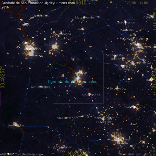
Analysis of Canindé de São Francisco night lights 2016
Square area 10x10 km:
 4.76%
4.76%90-99
8.23%80-89
1.95%70-79
5.41%60-69
8.87%50-59
11.9%40-49
11.04%30-39
9.52%20-29
17.1%10-19
20.56%0-9
0.65%Square area 50x50 km:
0.4%90-99
0.59%80-89
0.13%70-79
0.46%60-69
0.66%50-59
1.15%40-49
0.99%30-39
0.93%20-29
1.13%10-19
3.57%0-9
89.98%Clear (daylight) street map image can be seen on geolist.org.
Map coordinates:
8° 57' 58.1" South, 38° 29' 33.3" West
9° 39' 36" South, 37° 47' 22" West
10° 21' 8.7" South, 37° 5' 10.8" West
Some cities around Canindé de São Francisco sort by population:
• Paulo Afonso
54.5 km =33.9 mi,  301°
301°
• Delmiro Gouveia
37.9 km =23.5 mi,  322°
322°
• São José da Tapera
46.2 km =28.7 mi,  75°
75°
• Pão de Açúcar
39.9 km =24.8 mi,  104°
104°
• Porto da Folha
62.9 km =39.1 mi,  117°
117°
• Inhapi
49 km =30.4 mi,  5°
5°
• Monte Alegre de Sergipe
47.8 km =29.7 mi,  148°
148°
• Água Branca
47.2 km =29.3 mi,  340°
340°
3403344 (p: 11,052)
Sources (retrieved 2019-11-25):
» Earth at Night: Flat Maps 2012, 2016