Canhotinho night lights from space
Night Light of Canhotinho (Pernambuco) from space (Brazil) Src. Average luminocity for 10x10km area is 4.2835% and for 50x50km: 1.9381%.
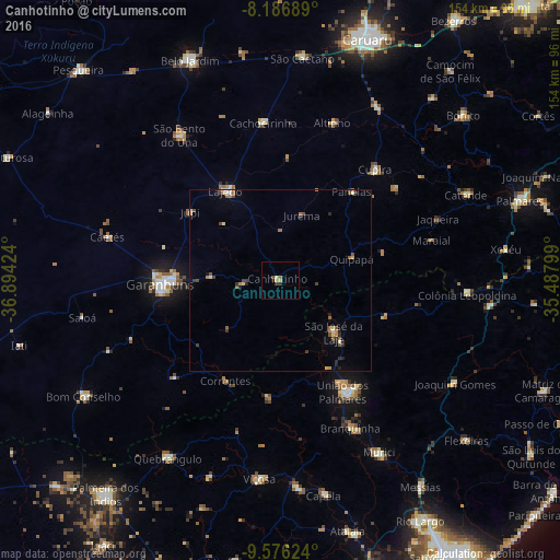
Analysis of Canhotinho night lights 2016
Square area 10x10 km:
 0%
0%90-99
0%80-89
1.73%70-79
0.87%60-69
0.43%50-59
0.87%40-49
0.43%30-39
1.52%20-29
0.22%10-19
0.87%0-9
93.07%Square area 50x50 km:
0.03%90-99
0.19%80-89
0.33%70-79
0.24%60-69
0.26%50-59
0.47%40-49
0.31%30-39
0.49%20-29
0.42%10-19
0.26%0-9
97%Clear (daylight) street map image can be seen on geolist.org.
Map coordinates:
8° 11' 12.8" South, 36° 53' 39.3" West
8° 52' 56" South, 36° 11' 28" West
9° 34' 34.5" South, 35° 29' 16.8" West
Some cities around Canhotinho sort by population:
• Garanhuns
34.2 km =21.3 mi,  270°
270°
• União dos Palmares
35.8 km =22.2 mi,  150°
150°
• Lajedo
28.1 km =17.5 mi,  329°
329°
• São José da Laje
20.3 km =12.6 mi,  134°
134°
• Quipapá
20.6 km =12.8 mi,  72°
72°
• Ibateguara
29.4 km =18.3 mi,  109°
109°
• São João
19.3 km =12 mi, 272°
• Santana do Mundaú
32 km =19.9 mi,  186°
186°
3403360 (p: 12,074)
Sources (retrieved 2019-11-25):
» Earth at Night: Flat Maps 2012, 2016