Amarante night lights from space
Night Light of Amarante (Piauí) from space (Brazil) Src. Average luminocity for 10x10km area is 9.2468% and for 50x50km: 1.0088%.
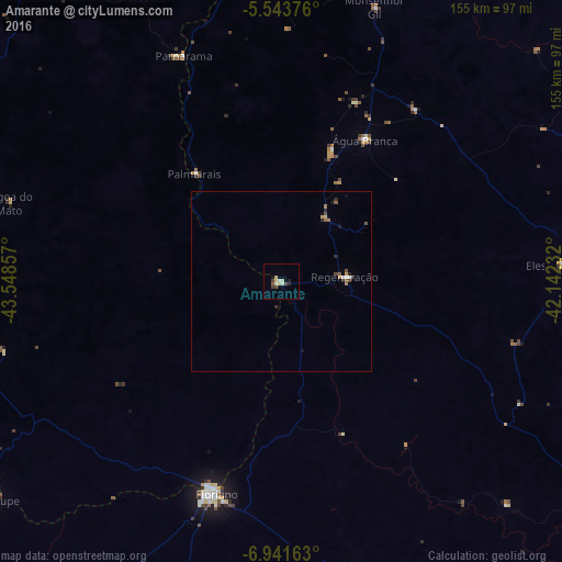
Analysis of Amarante night lights 2016
Square area 10x10 km:
 0.87%
0.87%90-99
1.73%80-89
3.46%70-79
0%60-69
0%50-59
0.87%40-49
1.73%30-39
1.73%20-29
1.08%10-19
0.65%0-9
87.88%Square area 50x50 km:
0.03%90-99
0.17%80-89
0.18%70-79
0.09%60-69
0.11%50-59
0.16%40-49
0.26%30-39
0.12%20-29
0.28%10-19
0.13%0-9
98.47%Clear (daylight) street map image can be seen on geolist.org.
Map coordinates:
5° 32' 37.5" South, 43° 32' 54.9" West
6° 14' 35.4" South, 42° 50' 43.6" West
6° 56' 29.9" South, 42° 8' 32.4" West
Some cities around Amarante sort by population:
• Floriano
61.4 km =38.2 mi,  198°
198°
• São João dos Patos
98.7 km =61.3 mi,  253°
253°
• Estreito
67.9 km =42.2 mi,  318°
318°
• Água Branca
45.4 km =28.2 mi,  30°
30°
• Regeneração
17.6 km =10.9 mi,  85°
85°
• Parnarama
68.2 km =42.4 mi,  336°
336°
• Elesbão Veloso
78.1 km =48.5 mi, 86°
• São Pedro do Piauí
37.6 km =23.4 mi,  21°
21°
3407756 (p: 8,828)
Sources (retrieved 2019-11-25):
» Earth at Night: Flat Maps 2012, 2016