Tarata night lights from space
Night Light of Tarata (Cochabamba) from space (Bolivia) Src. Average luminocity for 10x10km area is 12.4132% and for 50x50km: 16.5244%.
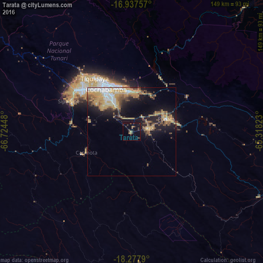
Analysis of Tarata night lights 2016
Square area 10x10 km:
 0%
0%90-99
0%80-89
1.86%70-79
0.62%60-69
2.48%50-59
0.83%40-49
2.69%30-39
7.23%20-29
1.24%10-19
10.74%0-9
72.31%Square area 50x50 km:
1.8%90-99
2.01%80-89
2.17%70-79
5.13%60-69
2.08%50-59
1.82%40-49
2.62%30-39
1.92%20-29
3.31%10-19
8.7%0-9
68.45%Clear (daylight) street map image can be seen on geolist.org.
Map coordinates:
16° 56' 15.3" South, 66° 43' 28.1" West
17° 36' 32.3" South, 66° 1' 16.9" West
18° 16' 40.4" South, 65° 19' 5.6" West
Some cities around Tarata sort by population:
• Cochabamba
28.3 km =17.6 mi,  329°
329°
• Sacaba
23.5 km =14.6 mi,  355°
355°
• Quillacollo
36.4 km =22.6 mi,  311°
311°
• Tiquipaya
36.5 km =22.7 mi, 325°
• Mizque
81 km =50.3 mi,  117°
117°
• Punata
21.1 km =13.1 mi,  69°
69°
• Cliza
9.7 km =6 mi,  75°
75°
• Capinota
27.8 km =17.3 mi,  245°
245°
3903342 (p: 8,043)
Sources (retrieved 2019-11-25):
» Earth at Night: Flat Maps 2012, 2016