Tutong night lights from space
Night Light of Tutong from space (Brunei) Src. Average luminocity for 10x10km area is 24.4628% and for 50x50km: 10.8911%.
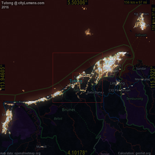
Analysis of Tutong night lights 2016
Square area 10x10 km:
 2.07%
2.07%90-99
2.07%80-89
2.07%70-79
4.34%60-69
6.61%50-59
3.31%40-49
2.27%30-39
2.48%20-29
0.83%10-19
44.01%0-9
29.96%Square area 50x50 km:
0.91%90-99
1.24%80-89
1.05%70-79
1.38%60-69
2.23%50-59
1.67%40-49
2.02%30-39
1.81%20-29
2.1%10-19
11%0-9
74.59%Clear (daylight) street map image can be seen on geolist.org.
Map coordinates:
5° 30' 11" North, 113° 56' 45.8" East
4° 48' 10" North, 114° 38' 57" East
4° 6' 6.4" North, 115° 21' 8.3" East
Some cities around Tutong sort by population:
• Marudi, MY
78.1 km =48.5 mi,  208°
208°
• Labuan, MY
84.9 km =52.8 mi,  51°
51°
• Bandar Seri Begawan
33.7 km =20.9 mi,  73°
73°
• Lawas, MY
84.4 km =52.4 mi,  85°
85°
• Kuala Belait
52.3 km =32.5 mi,  242°
242°
• Seria
42.1 km =26.2 mi, 238°
• Limbang, MY
39.3 km =24.4 mi,  98°
98°
• Bangar
48 km =29.8 mi, 102°
1820071 (p: 19,151)
Sources (retrieved 2019-11-25):
» Earth at Night: Flat Maps 2012, 2016