Zlatni Pyasatsi night lights from space
Night Light of Zlatni Pyasatsi (Varna) from space (Bulgaria) Src. Average luminocity for 10x10km area is 12.1076% and for 50x50km: 5.8763%.
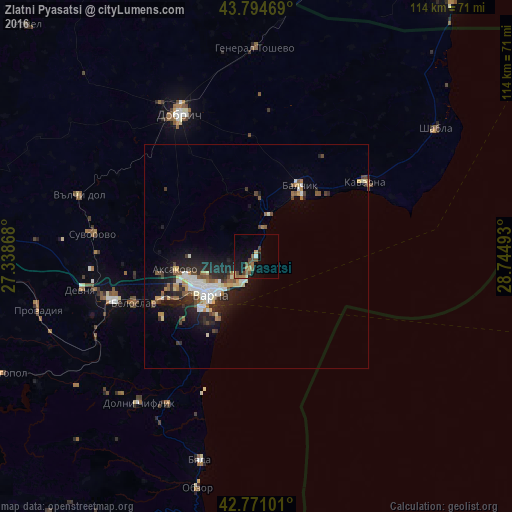
Analysis of Zlatni Pyasatsi night lights 2016
Square area 10x10 km:
 0.3%
0.3%90-99
0.3%80-89
2.12%70-79
0.91%60-69
3.33%50-59
2.88%40-49
3.64%30-39
0.45%20-29
0.91%10-19
10.61%0-9
74.55%Square area 50x50 km:
0.84%90-99
1.01%80-89
0.61%70-79
0.52%60-69
0.68%50-59
0.86%40-49
0.78%30-39
0.66%20-29
2.24%10-19
4.04%0-9
87.76%Clear (daylight) street map image can be seen on geolist.org.
Map coordinates:
43° 47' 40.9" North, 27° 20' 19.2" East
43° 17' 6" North, 28° 2' 30.5" East
42° 46' 15.6" North, 28° 44' 41.7" East
Some cities around Zlatni Pyasatsi sort by population:
• Varna
12.7 km =7.9 mi,  233°
233°
• Dobrich
35.6 km =22.1 mi,  331°
331°
• Asparuhovo
17 km =10.6 mi, 227°
• Balchik
17.9 km =11.1 mi,  31°
31°
• Kavarna
29.3 km =18.2 mi,  55°
55°
• Devnya
38.9 km =24.2 mi,  259°
259°
• Beloslav
29.3 km =18.2 mi,  248°
248°
• Aksakovo
18.2 km =11.3 mi, 259°
6355004 (p: 9,760)
Sources (retrieved 2019-11-25):
» Earth at Night: Flat Maps 2012, 2016