Elin Pelin night lights from space
Night Light of Elin Pelin (Sofia) from space (Bulgaria) Src. Average luminocity for 10x10km area is 18.4318% and for 50x50km: 12.1032%.
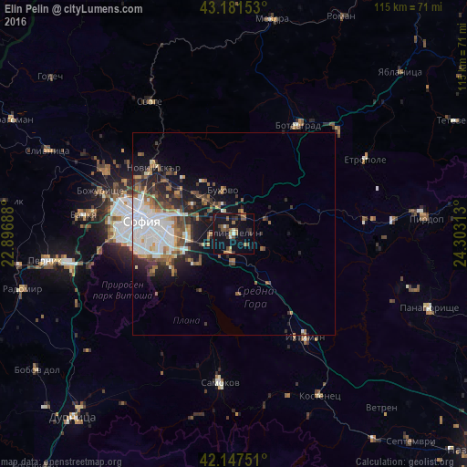
Analysis of Elin Pelin night lights 2016
Square area 10x10 km:
 0.61%
0.61%90-99
1.52%80-89
0.91%70-79
2.27%60-69
3.33%50-59
5.3%40-49
2.73%30-39
2.73%20-29
2.42%10-19
27.88%0-9
50.3%Square area 50x50 km:
2.84%90-99
2.33%80-89
0.72%70-79
1.08%60-69
1.43%50-59
2.14%40-49
1.69%30-39
1.68%20-29
3.01%10-19
5.94%0-9
77.16%Clear (daylight) street map image can be seen on geolist.org.
Map coordinates:
43° 10' 53.5" North, 22° 53' 48.8" East
42° 40' 0" North, 23° 36' 0" East
42° 8' 51" North, 24° 18' 11.3" East
Some cities around Elin Pelin sort by population:
• Sofia
22.8 km =14.2 mi,  278°
278°
• Samokov
36.9 km =22.9 mi,  186°
186°
• Botevgrad
29.9 km =18.6 mi,  29°
29°
• Ihtiman
31.4 km =19.5 mi,  145°
145°
• Kostinbrod
35.5 km =22.1 mi,  298°
298°
• Etropole
37.6 km =23.4 mi,  60°
60°
• Svoge
39.1 km =24.3 mi,  328°
328°
• Zlatitsa
43.9 km =27.3 mi,  82°
82°
731675 (p: 7,373)
Sources (retrieved 2019-11-25):
» Earth at Night: Flat Maps 2012, 2016