Kostinbrod night lights from space
Night Light of Kostinbrod (Sofia) from space (Bulgaria) Src. Average luminocity for 10x10km area is 16.0652% and for 50x50km: 16.3971%.
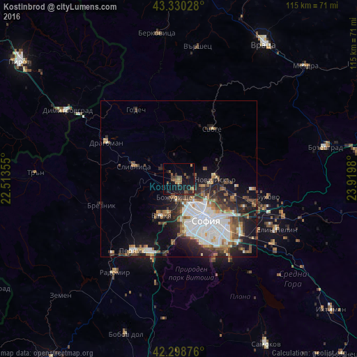
Analysis of Kostinbrod night lights 2016
Square area 10x10 km:
 0%
0%90-99
0%80-89
0%70-79
2.12%60-69
3.79%50-59
5.3%40-49
3.48%30-39
2.42%20-29
6.82%10-19
22.27%0-9
53.79%Square area 50x50 km:
4.07%90-99
3.48%80-89
0.92%70-79
1.32%60-69
2%50-59
2.56%40-49
2.03%30-39
2.37%20-29
4.57%10-19
7.43%0-9
69.25%Clear (daylight) street map image can be seen on geolist.org.
Map coordinates:
43° 19' 49" North, 22° 30' 48.8" East
42° 49' 0" North, 23° 13' 0" East
42° 17' 55.5" North, 23° 55' 11.3" East
Some cities around Kostinbrod sort by population:
• Sofia
15.9 km =9.9 mi,  146°
146°
• Pernik
28.4 km =17.6 mi,  211°
211°
• Radomir
36.5 km =22.7 mi, 214°
• Svoge
19.9 km =12.4 mi,  33°
33°
• Slivnitsa
15.1 km =9.4 mi,  285°
285°
• Varshets
42.3 km =26.3 mi,  7°
7°
• Elin Pelin
35.5 km =22.1 mi,  118°
118°
• Godech
26.1 km =16.2 mi,  328°
328°
730084 (p: 12,175)
Sources (retrieved 2019-11-25):
» Earth at Night: Flat Maps 2012, 2016