Heers night lights from space
Night Light of Heers (Flanders) from space (Belgium) Src. Average luminocity for 10x10km area is 17.131% and for 50x50km: 29.6952%.
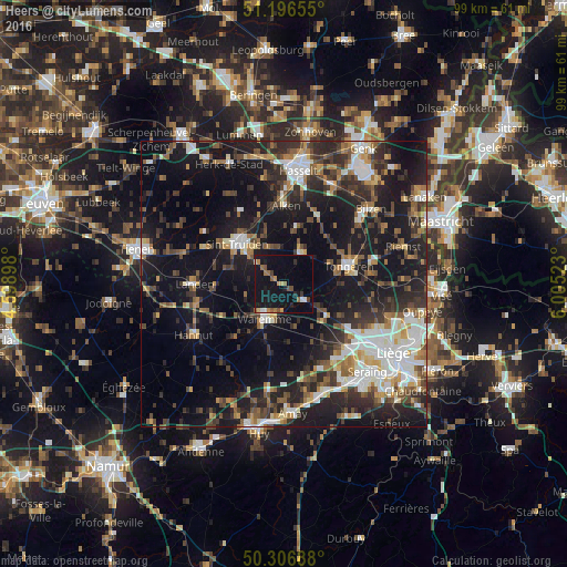
Analysis of Heers night lights 2016
Square area 10x10 km:
 0.53%
0.53%90-99
1.6%80-89
1.2%70-79
2.14%60-69
3.07%50-59
2.67%40-49
2.01%30-39
1.34%20-29
2.81%10-19
30.48%0-9
52.14%Square area 50x50 km:
4.56%90-99
5.25%80-89
2.24%70-79
2.71%60-69
3.51%50-59
4.12%40-49
5.15%30-39
5.45%20-29
9.93%10-19
26.15%0-9
30.94%Clear (daylight) street map image can be seen on geolist.org.
Map coordinates:
51° 11' 47.6" North, 4° 35' 56.3" East
50° 45' 13.8" North, 5° 18' 7.6" East
50° 18' 24.8" North, 6° 0' 18.8" East
Some cities around Heers sort by population:
• Sint-Truiden
10.7 km =6.6 mi,  310°
310°
• Tongeren
11.8 km =7.3 mi,  75°
75°
• Waremme
7.1 km =4.4 mi,  207°
207°
• Borgloon
6.4 km =4 mi,  27°
27°
• Kortessem
13.2 km =8.2 mi, 27°
• Gingelom
11.8 km =7.3 mi,  266°
266°
• Wellen
10 km =6.2 mi,  14°
14°
• Remicourt
8.3 km =5.2 mi,  167°
167°
2796297 (p: 6,689)
Sources (retrieved 2019-11-25):
» Earth at Night: Flat Maps 2012, 2016