Visé night lights from space
Night Light of Visé (Wallonia) from space (Belgium) Src. Average luminocity for 10x10km area is 35.389% and for 50x50km: 33.7487%.
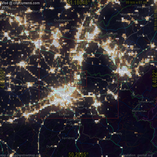
Analysis of Visé night lights 2016
Square area 10x10 km:
100  4.41%
4.41%
90-99 5.61%
80-89 1.47%
70-79 3.61%
60-69 7.35%
50-59 4.95%
40-49 5.48%
30-39 10.56%
20-29 18.45%
10-19 20.32%
0-9 17.78%
4.41%90-99
5.61%80-89
1.47%70-79
3.61%60-69
7.35%50-59
4.95%40-49
5.48%30-39
10.56%20-29
18.45%10-19
20.32%0-9
17.78%Square area 50x50 km:
100 5.56%
90-99 6.97%
80-89 2.81%
70-79 3.07%
60-69 4.19%
50-59 4.71%
40-49 4.93%
30-39 6.24%
20-29 12.11%
10-19 23.84%
0-9 25.57%
5.56%90-99
6.97%80-89
2.81%70-79
3.07%60-69
4.19%50-59
4.71%40-49
4.93%30-39
6.24%20-29
12.11%10-19
23.84%0-9
25.57%Clear (daylight) street map image can be seen on geolist.org.
Map coordinates:
51° 10' 49.7" North, 4° 59' 45.4" East
50° 44' 15.4" North, 5° 41' 56.7" East
50° 17' 25.8" North, 6° 24' 7.9" East
Some cities around Visé sort by population:
• Herstal
9.7 km =6 mi,  213°
213°
• Oupeye
4.7 km =2.9 mi,  232°
232°
• Riemst
10.6 km =6.6 mi,  319°
319°
• Blégny
7.5 km =4.7 mi,  165°
165°
• Eijsden, NL
4.9 km =3 mi,  15°
15°
• Bassenge
6.7 km =4.2 mi,  290°
290°
• Dalhem
3.4 km =2.1 mi,  143°
143°
• De Heeg, NL
9.8 km =6.1 mi,  9°
9°
2784548 (p: 17,054)
Sources (retrieved 2019-11-25):
» Earth at Night: Flat Maps 2012, 2016