Eijsden night lights from space
Night Light of Eijsden (Limburg) from space (Netherlands) Src. Average luminocity for 10x10km area is 30.0644% and for 50x50km: 36.7492%.
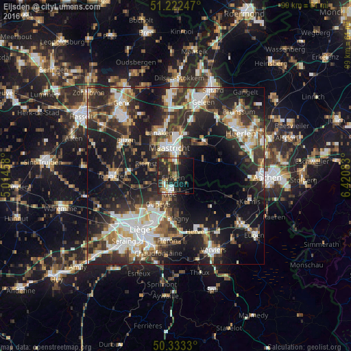
Analysis of Eijsden night lights 2016
Square area 10x10 km:
100  3.5%
3.5%
90-99 4.62%
80-89 1.26%
70-79 3.5%
60-69 5.6%
50-59 3.36%
40-49 2.38%
30-39 6.02%
20-29 25.91%
10-19 19.61%
0-9 24.23%
3.5%90-99
4.62%80-89
1.26%70-79
3.5%60-69
5.6%50-59
3.36%40-49
2.38%30-39
6.02%20-29
25.91%10-19
19.61%0-9
24.23%Square area 50x50 km:
100 6.34%
90-99 7.91%
80-89 3.06%
70-79 3.45%
60-69 4.79%
50-59 4.98%
40-49 5.05%
30-39 6.96%
20-29 13.18%
10-19 22.66%
0-9 21.62%
6.34%90-99
7.91%80-89
3.06%70-79
3.45%60-69
4.79%50-59
4.98%40-49
5.05%30-39
6.96%20-29
13.18%10-19
22.66%0-9
21.62%Clear (daylight) street map image can be seen on geolist.org.
Map coordinates:
51° 13' 20.9" North, 5° 0' 52.5" East
50° 46' 48" North, 5° 43' 3.7" East
50° 19' 59.9" North, 6° 25' 15" East
Some cities around Eijsden sort by population:
• Maastricht
7.9 km =4.9 mi,  345°
345°
• Visé, BE
4.9 km =3 mi,  195°
195°
• Riemst, BE
8.8 km =5.5 mi,  292°
292°
• Bassenge, BE
7.9 km =4.9 mi,  252°
252°
• Heer
6.5 km =4 mi,  7°
7°
• Scharn
7.9 km =4.9 mi, 8°
• Dalhem, BE
7.5 km =4.7 mi,  174°
174°
• De Heeg
5 km =3.1 mi,  4°
4°
2756283 (p: 11,795)
Sources (retrieved 2019-11-25):
» Earth at Night: Flat Maps 2012, 2016