Quévy-le-Petit night lights from space
Night Light of Quévy-le-Petit (Wallonia) from space (Belgium) Src. Average luminocity for 10x10km area is 21.8445% and for 50x50km: 24.8215%.
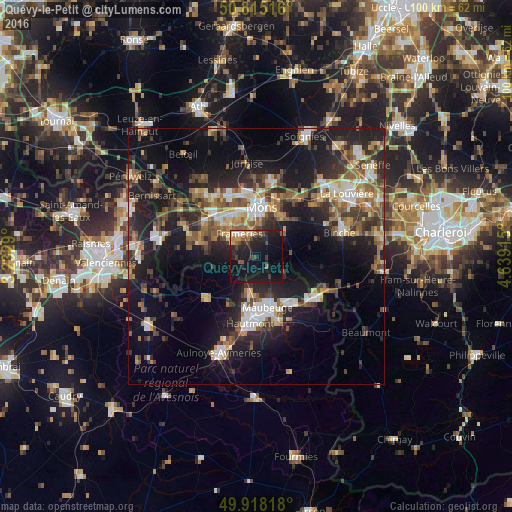
Analysis of Quévy-le-Petit night lights 2016
Square area 10x10 km:
 0.56%
0.56%90-99
2.24%80-89
1.4%70-79
2.66%60-69
1.96%50-59
3.36%40-49
3.5%30-39
4.2%20-29
11.34%10-19
41.88%0-9
26.89%Square area 50x50 km:
2.86%90-99
3.83%80-89
2.31%70-79
2.78%60-69
3.61%50-59
4.31%40-49
4.38%30-39
4.41%20-29
8.57%10-19
19.08%0-9
43.87%Clear (daylight) street map image can be seen on geolist.org.
Map coordinates:
50° 48' 54.6" North, 3° 13' 58.4" East
50° 22' 7.6" North, 3° 56' 9.7" East
49° 55' 5.4" North, 4° 38' 20.9" East
Some cities around Quévy-le-Petit sort by population:
• Mons
9.6 km =6 mi,  6°
6°
• Maubeuge, FR
10.3 km =6.4 mi,  165°
165°
• Frameries
5 km =3.1 mi,  325°
325°
• Colfontaine
7.6 km =4.7 mi,  311°
311°
• Quaregnon
9.4 km =5.8 mi, 327°
• Dour
11.6 km =7.2 mi,  285°
285°
• Feignies, FR
8 km =5 mi,  190°
190°
• Chasse Royale
6.7 km =4.2 mi, 8°
2788446 (p: 7,689)
Sources (retrieved 2019-11-25):
» Earth at Night: Flat Maps 2012, 2016